Sustainable Food Estates
Implementation, impacts and opportunities
Sustainable Food Estates
Implementation, impacts and opportunities
December 1, 2025
LEAF Indonesia, funded by the Global Centre on Biodiversity for Climate (GCBC), is a transdisciplinary research partnership between the University of Sussex, Monash University, Universitas Negeri Gorontalo, Universitas Papua, and Universitas Mulawarman.
You are viewing a Storymap which introduces the results of our first phase of work with Indonesian farming communities, government agencies, NGOs, and conservation organizations to find ways to balance Indonesia’s food security goals with environmental protection, climate resilience, and the well-being of local communities.
Scroll down to reveal the story. You can navigate to any part of the story using the dropdown table of contents at the top right of the screen.


Introduction
In April 2020, four months into the COVID-19 pandemic, the World Food Programme published a report outlining the likely food security implications of the unfolding crisis due to the disruption of global trade, humanitarian actions, and food production, as well as impacts on health and poverty for millions of the world’s poorest.
Partly in reaction to this report, in June 2020, Indonesia’s President Jokowi announced plans for an expansion of the Food Estate Program to ensure Indonesia’s future food self-sufficiency.
Led by then-defence Minister Prabowo, the program was intended to convert four million hectares of land for food production by 2029, thereby increasing rice production by 10 million tons annually and, ultimately, achieving rice self-sufficiency.
How could this be done in a way that genuinely improves food security for Indonesians, especially the poorest? And what would such a massive change in land-use mean for biodiversity, climate change and livelihoods?
What would it mean for one of the world’s largest, most populous and most biodiverse countries to transform its national food system from a mosaic of smallholder farms and export oriented commercial plantations into a self-sufficient modernized agricultural powerhouse?
To begin to answer this question we will take you through an overview of Indonesia’s food security challenge and tell you the story of how the food estate idea came to take on such a central role in Indonesian policy. Finally, we will introduce you to the three provinces where we are working with rural communities to understand the impacts of food estates on biodiversity, climate resilience and livelihoods and to try to imagine a more sustainable model for food estates into the future.
The Challenge of Feeding an Archipelago
Indonesia is a vast archipelago stretching from the northern coast of Australia to the east coast of Malaysia.
It is the world’s largest island nation with a land area more than 5 times that of Germany spread over 17,000 islands.
The distance from one end to the other is 5,000 km and spans nearly one-tenth of the equator.
Home to 280 million people, it is the fourth most populous nation in the world.
Indonesia’s challenge to feed its vast archipelago is shaped by a convergence of environmental pressures, livelihood strains, land dilemmas, and governance gaps. On the environmental front, the country faces increasing floods, droughts, and forest fires that disrupt farming cycles and destroy harvests. Deforestation for plantations reduces arable land and alters rainfall, while soil degradation lowers productivity and biodiversity loss undermines resilience against pests and climate shocks. These ecological stresses weaken the very foundations of food production.
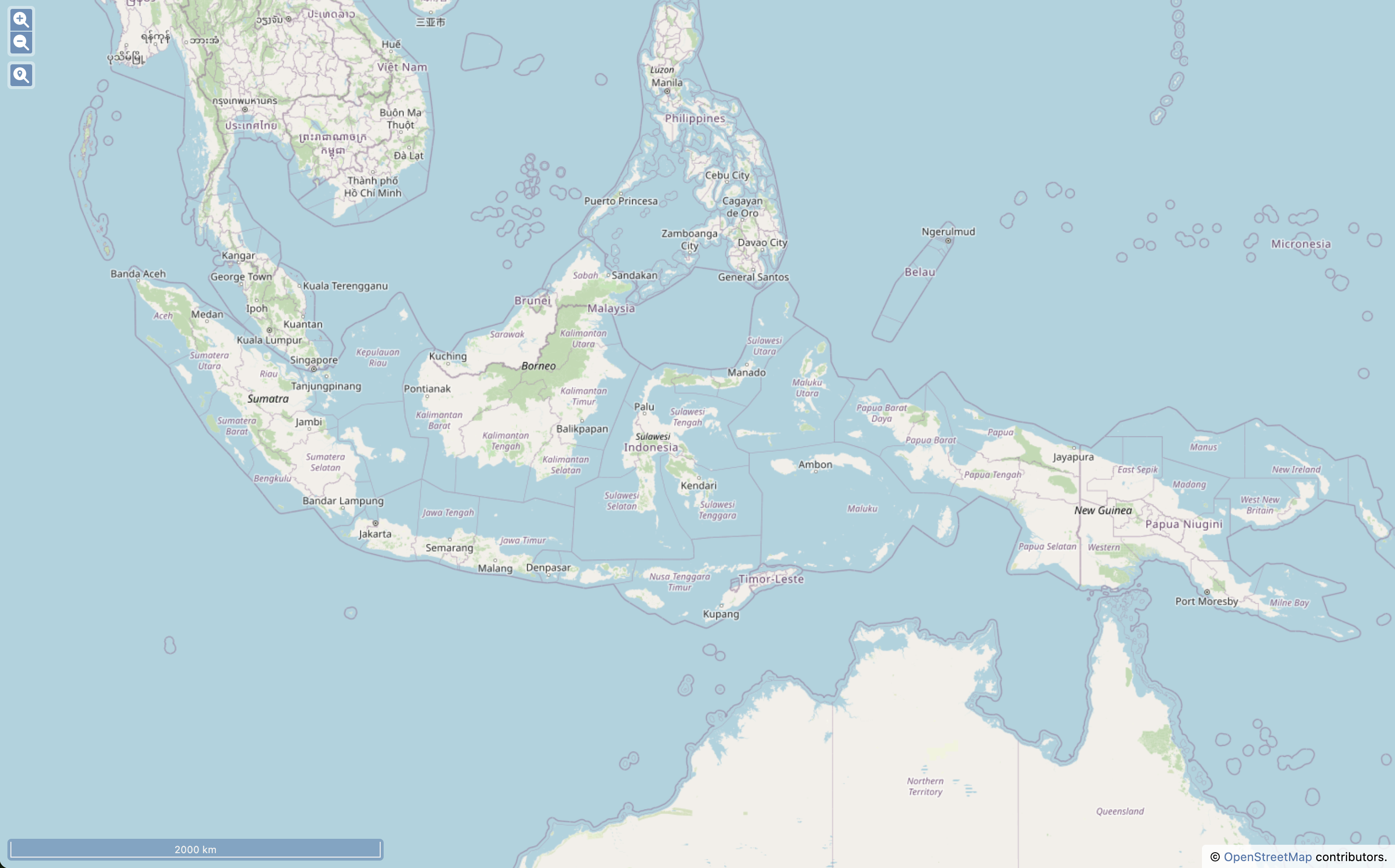
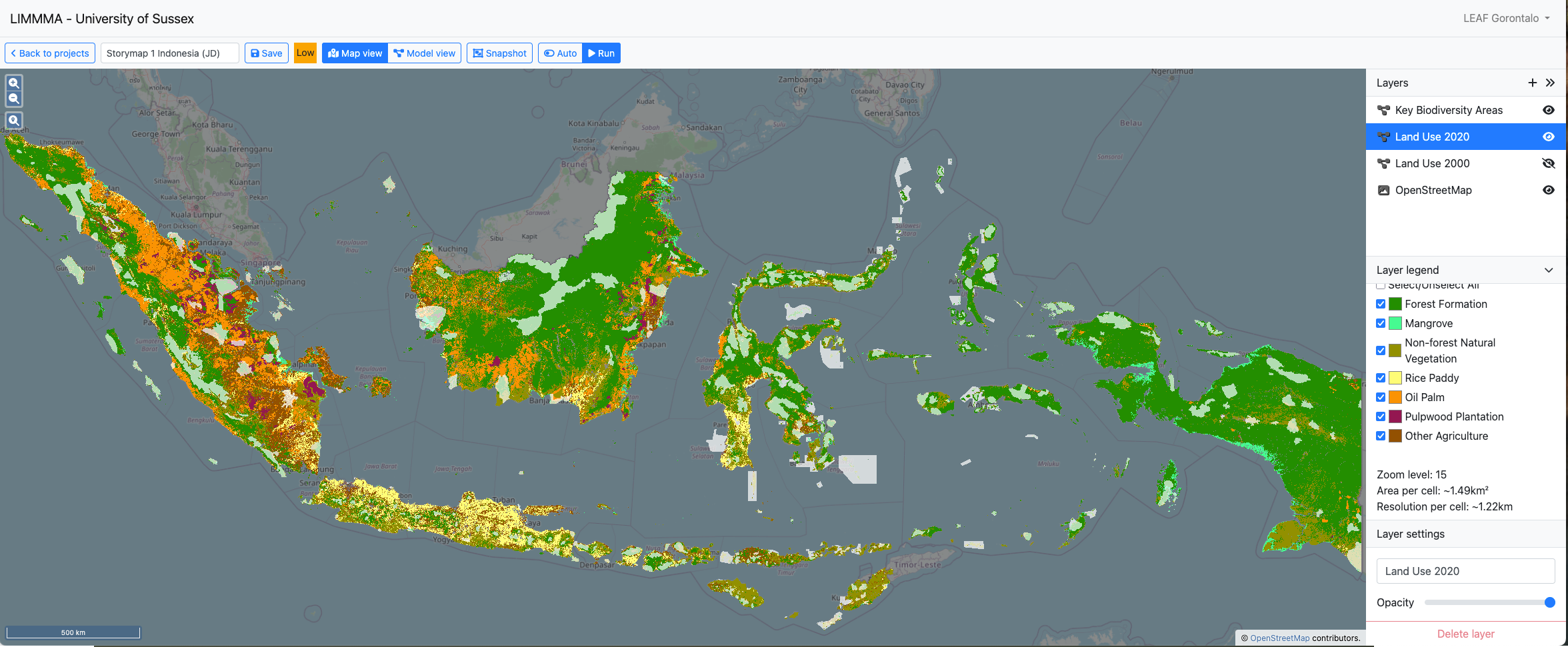
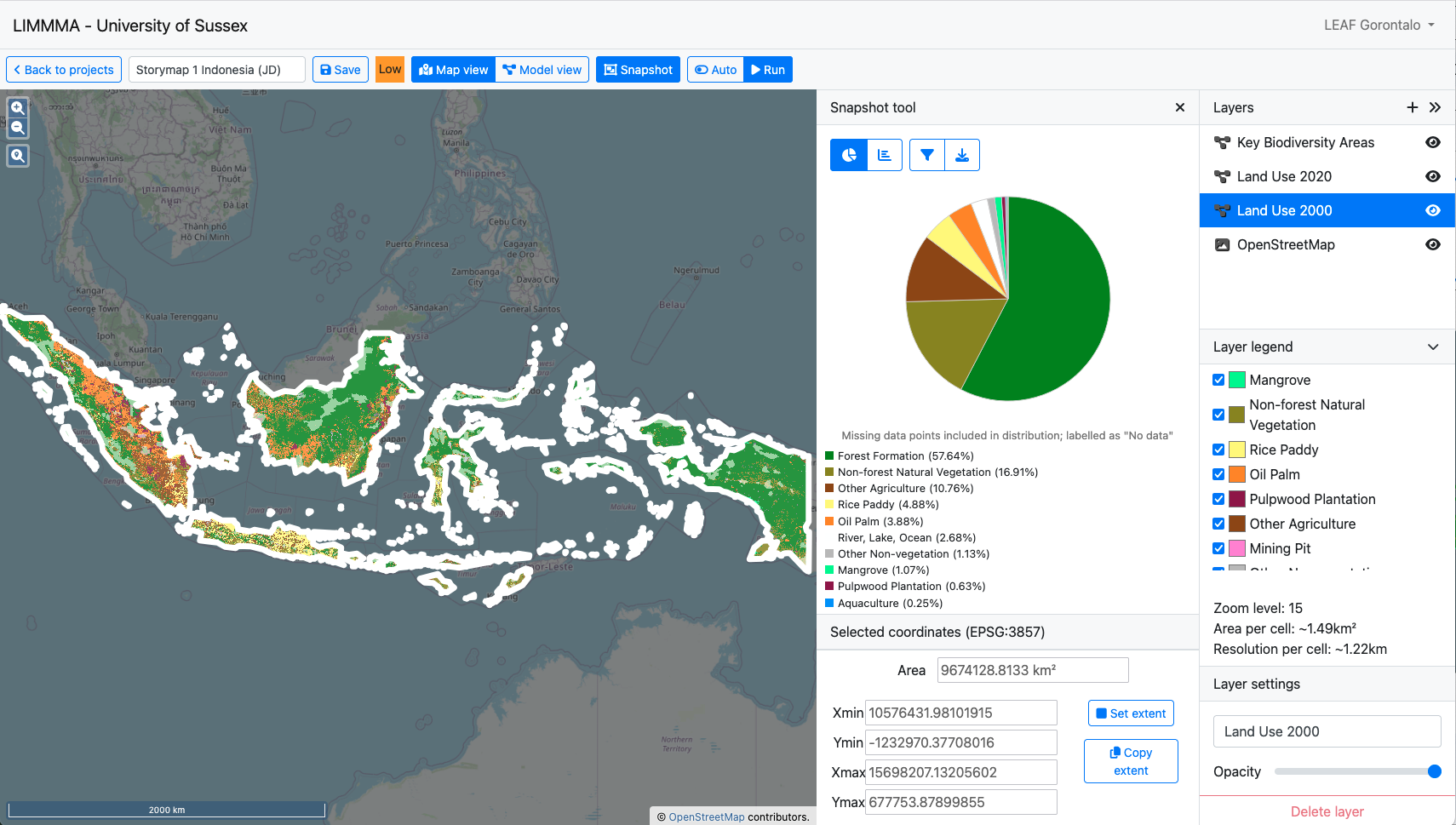
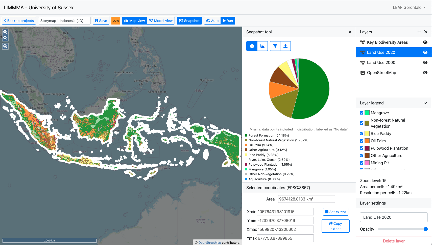
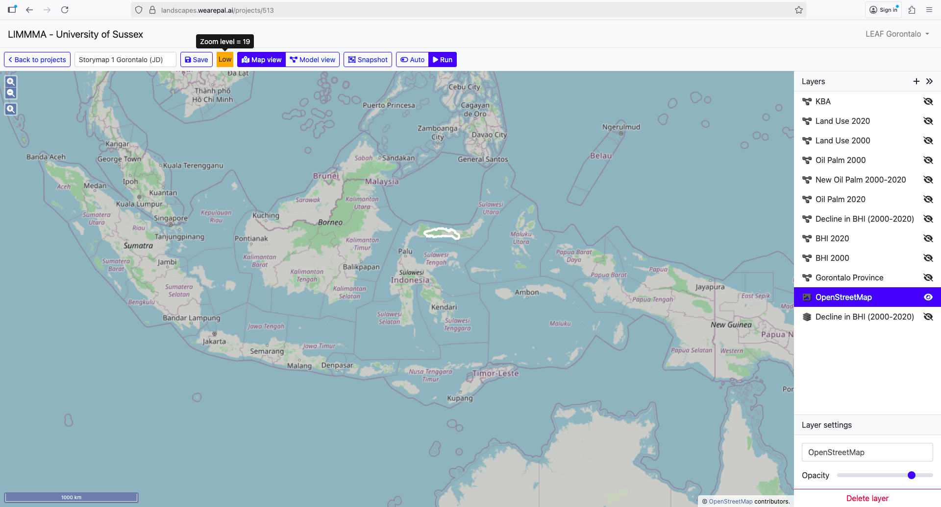
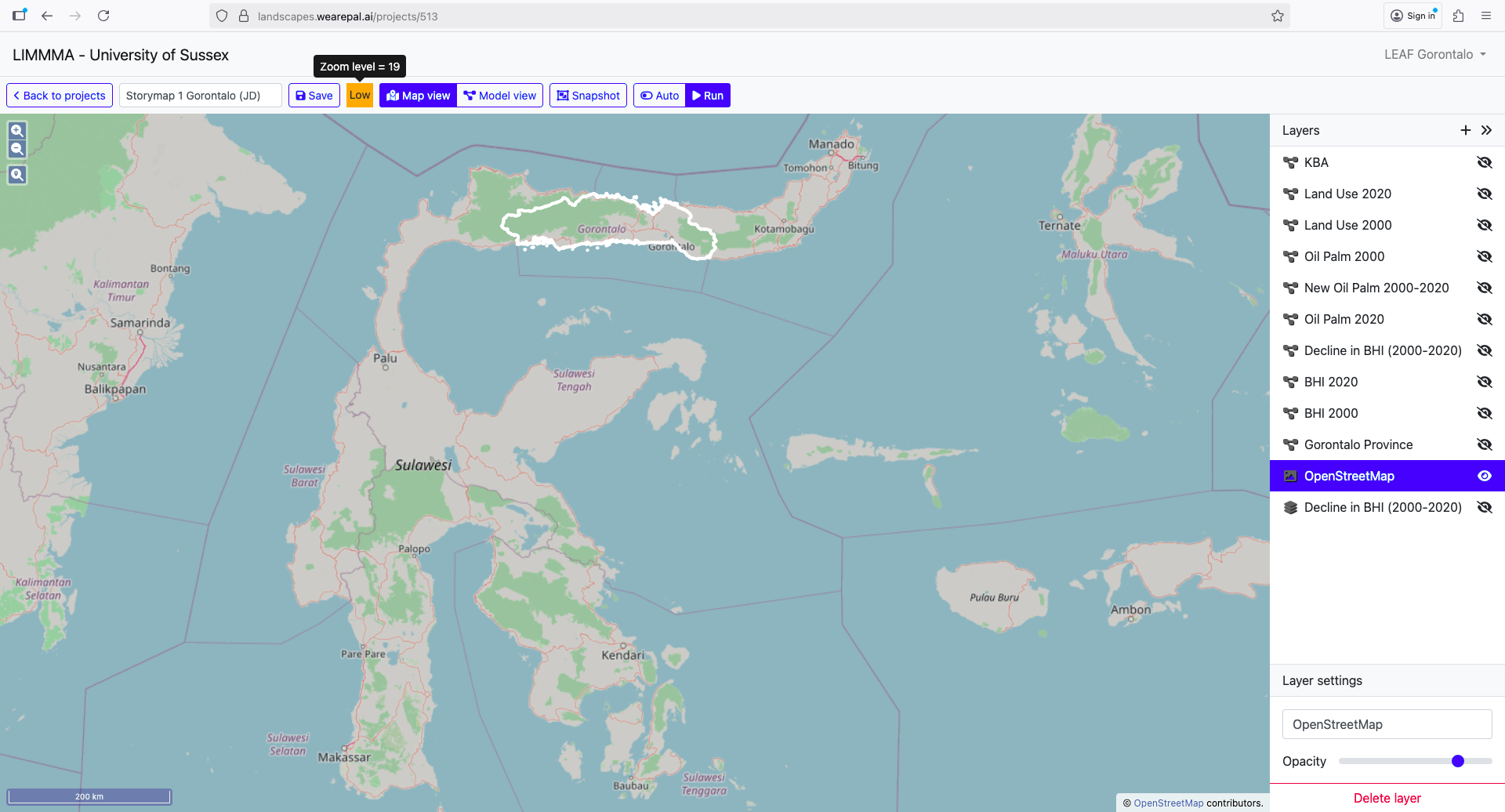
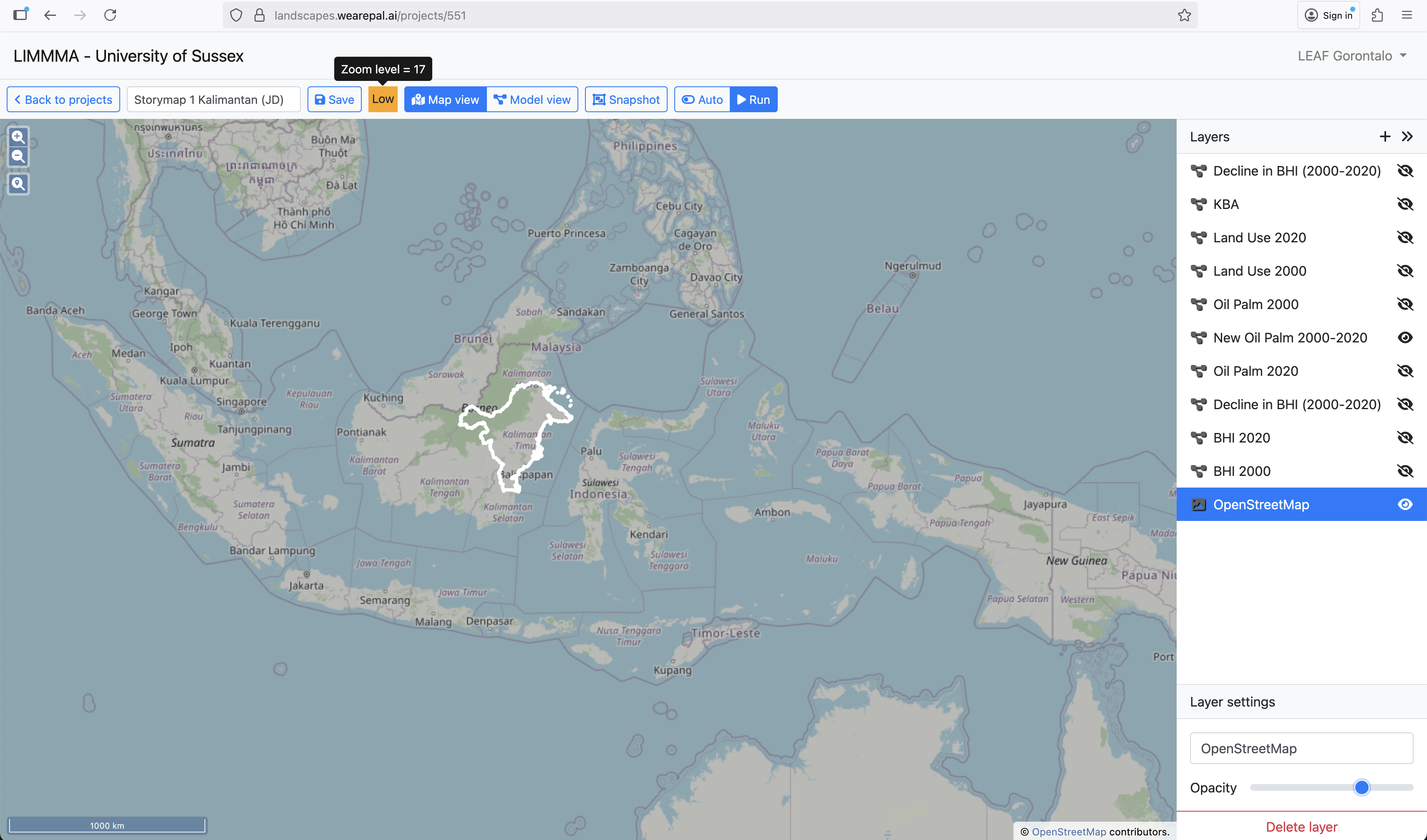
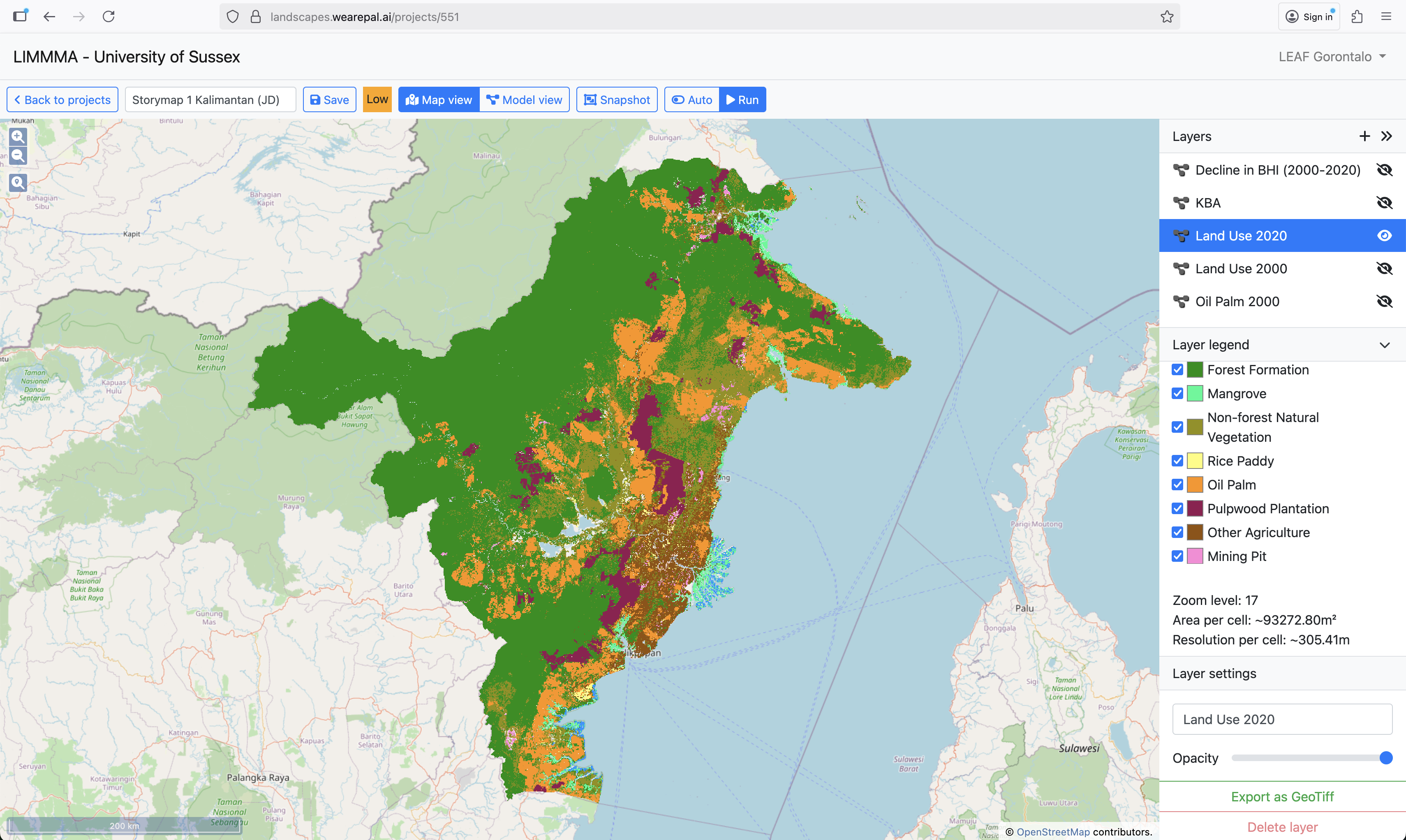
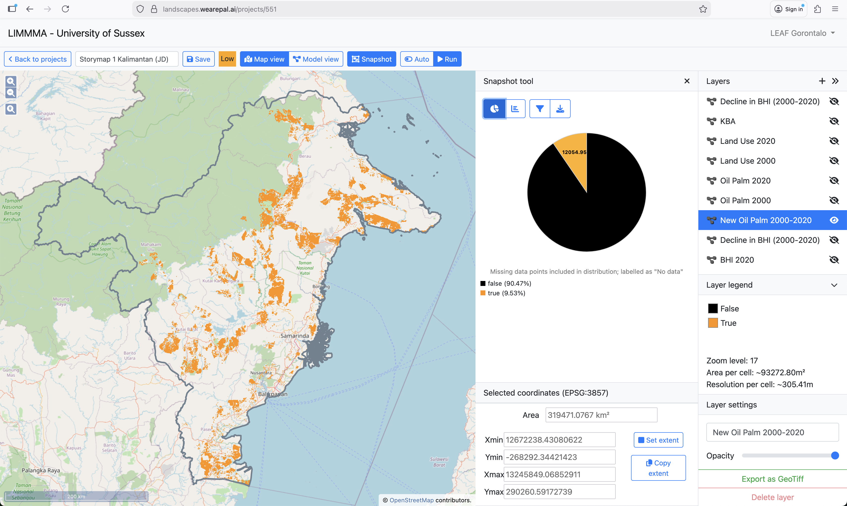
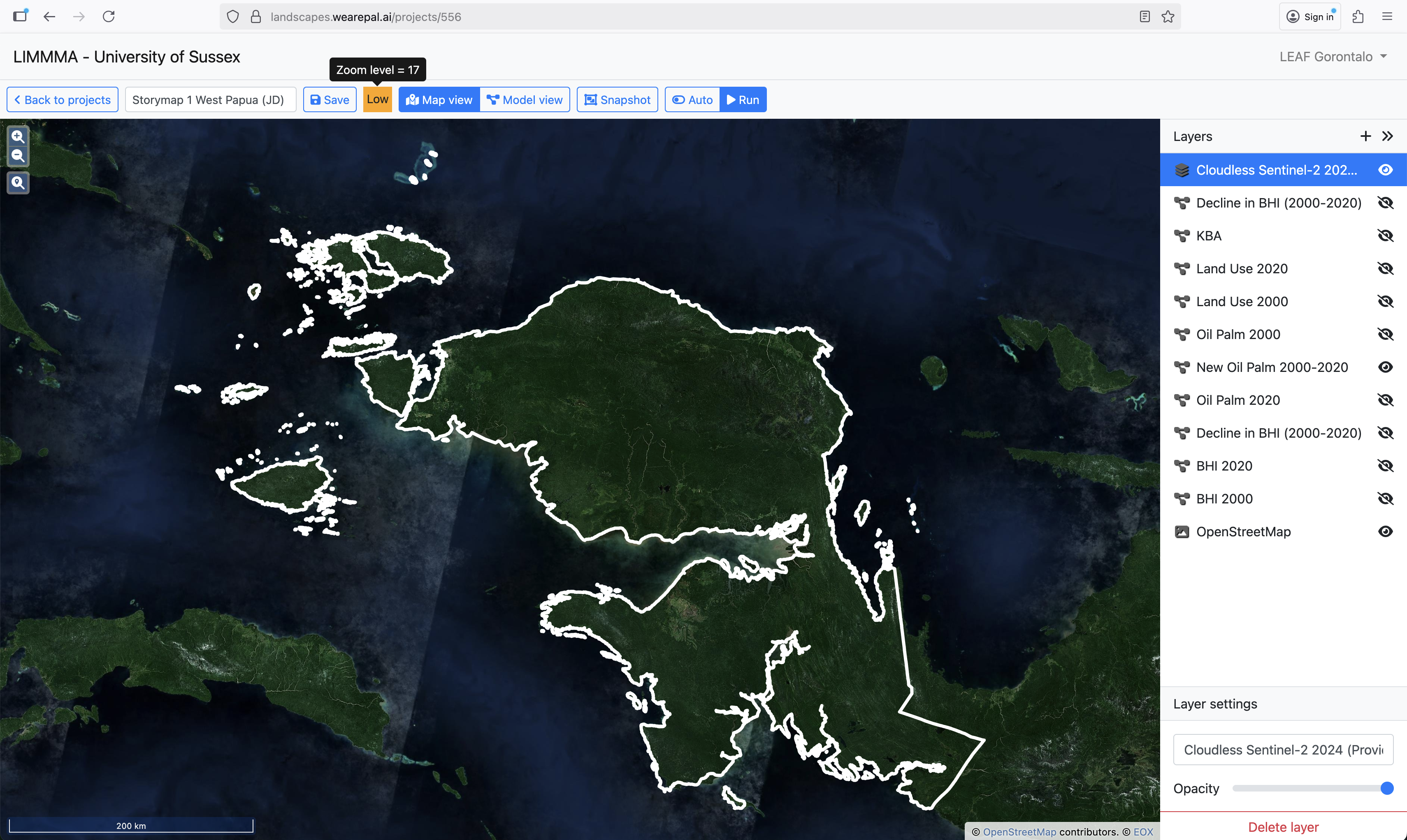
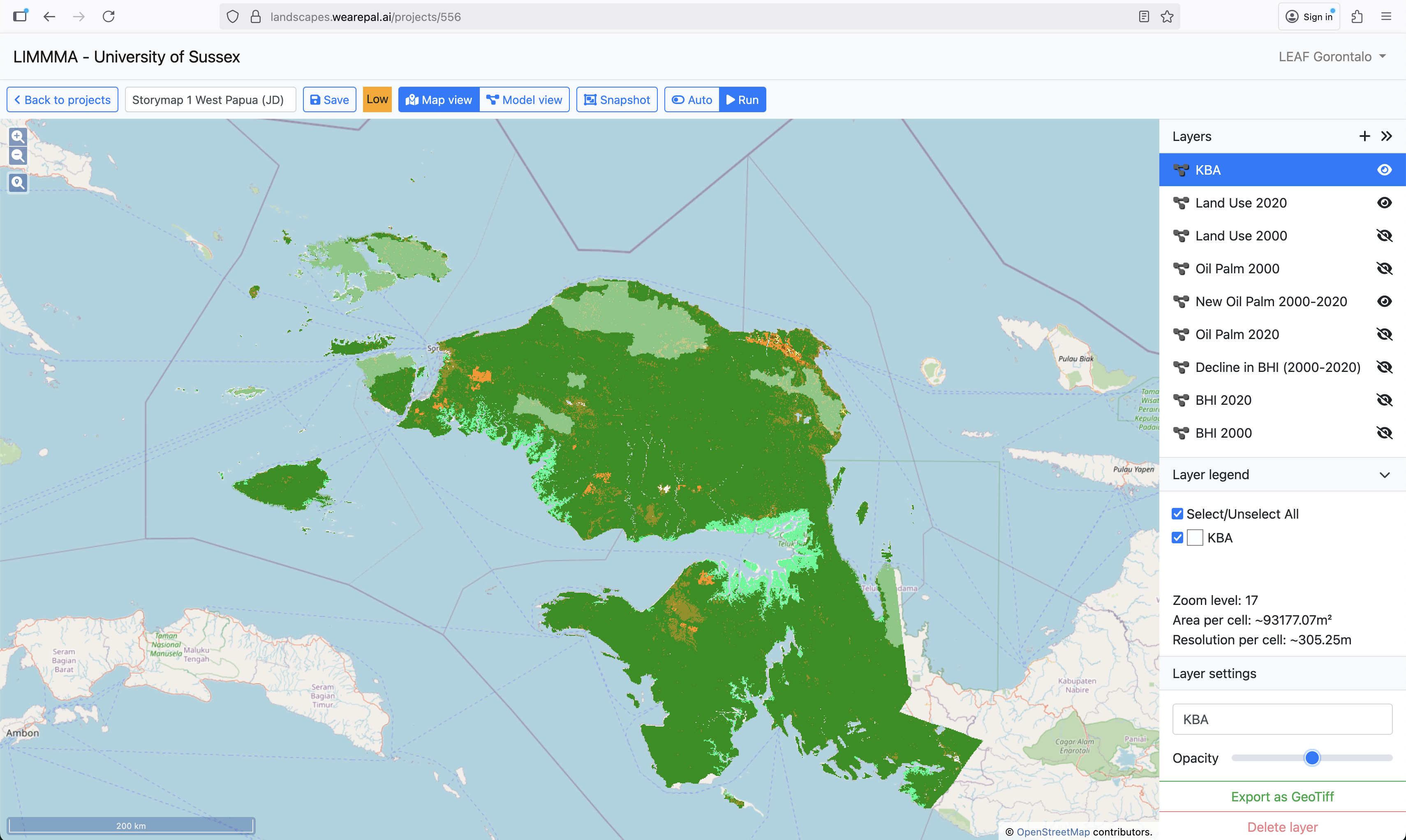
Impacts of land-use change on competition for farmland
This map from LIMMMA helps to visualise the challenge of balancing export agriculture and food crops in the context of Indonesia’s rich biodiversity.
It shows different land-uses (including Oil Palm, Pulpwood Plantations, Rice Paddy and Other Agriculture) overlaid with Key Biodiversity Areas (semi-transparent white) as of 2020.
In Gorontalo, one of our case study locations, corn is the dominant crop and agroforestry is also widespread. Although these are invisible in the current land-use classifications since they are subsumed under ‘Other agriculture’ and ‘Forest formation’.
Notice how Oil Palm and Pulpwood plantations dominate the islands of Sumatra…
…and Kalimantan, while frequently overlapping with Key Biodiversity Areas.
The majority of Rice Paddies are on Java (centre bottom) while also squeezed onto the peripheries of Sumatra, Kalimantan and Sulawesi (centre).
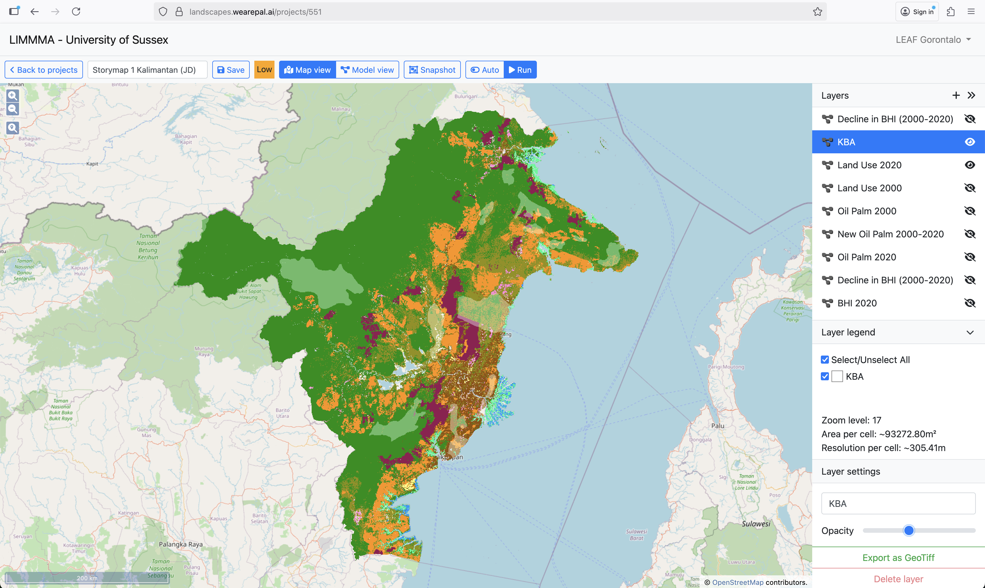
This interactive section allows you to view the pattern of land use across Indonesia by zooming in and out and panning around.
When you have finished, simply move the mouse to the right hand menu bar and scroll down to move to the next section.
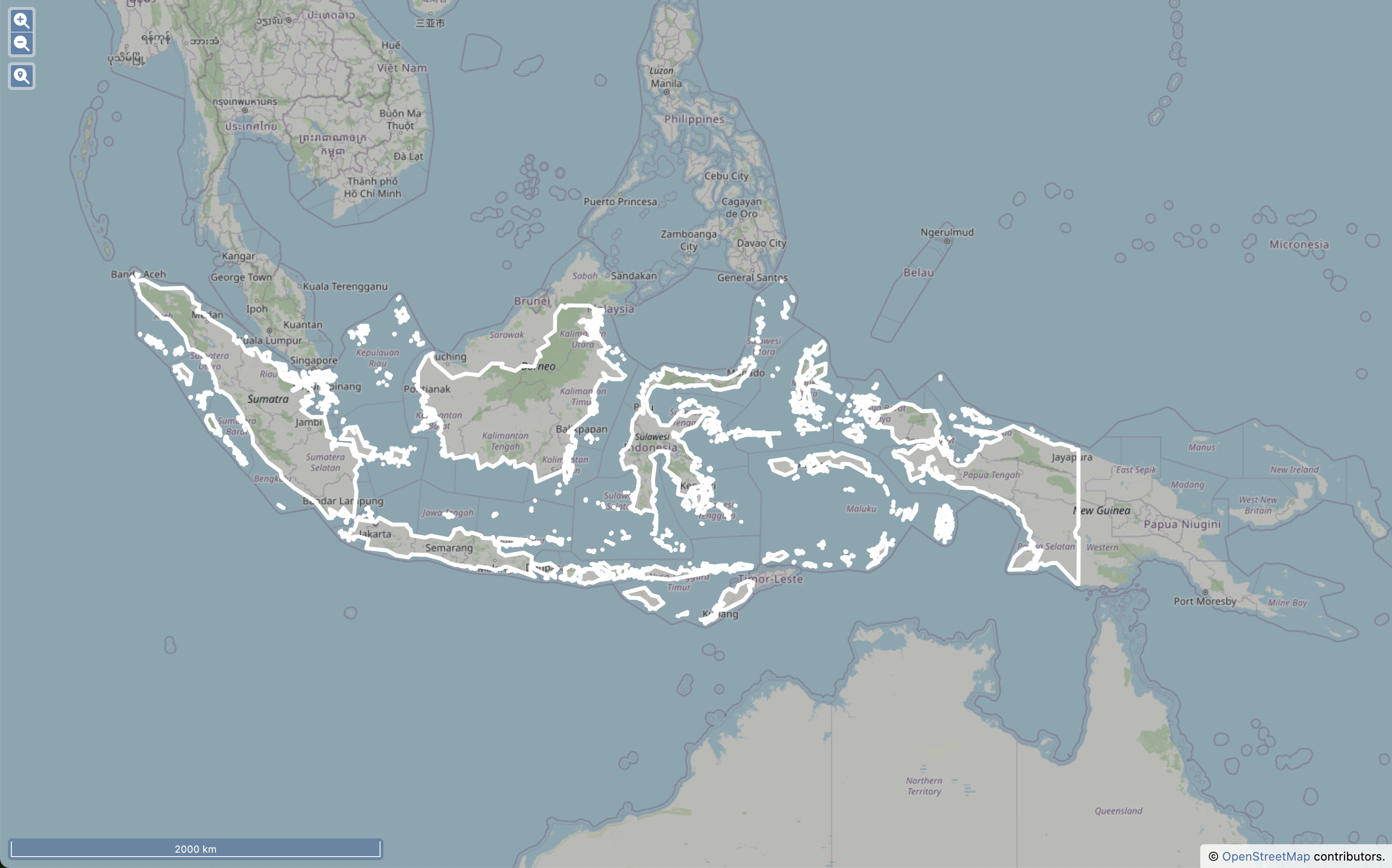
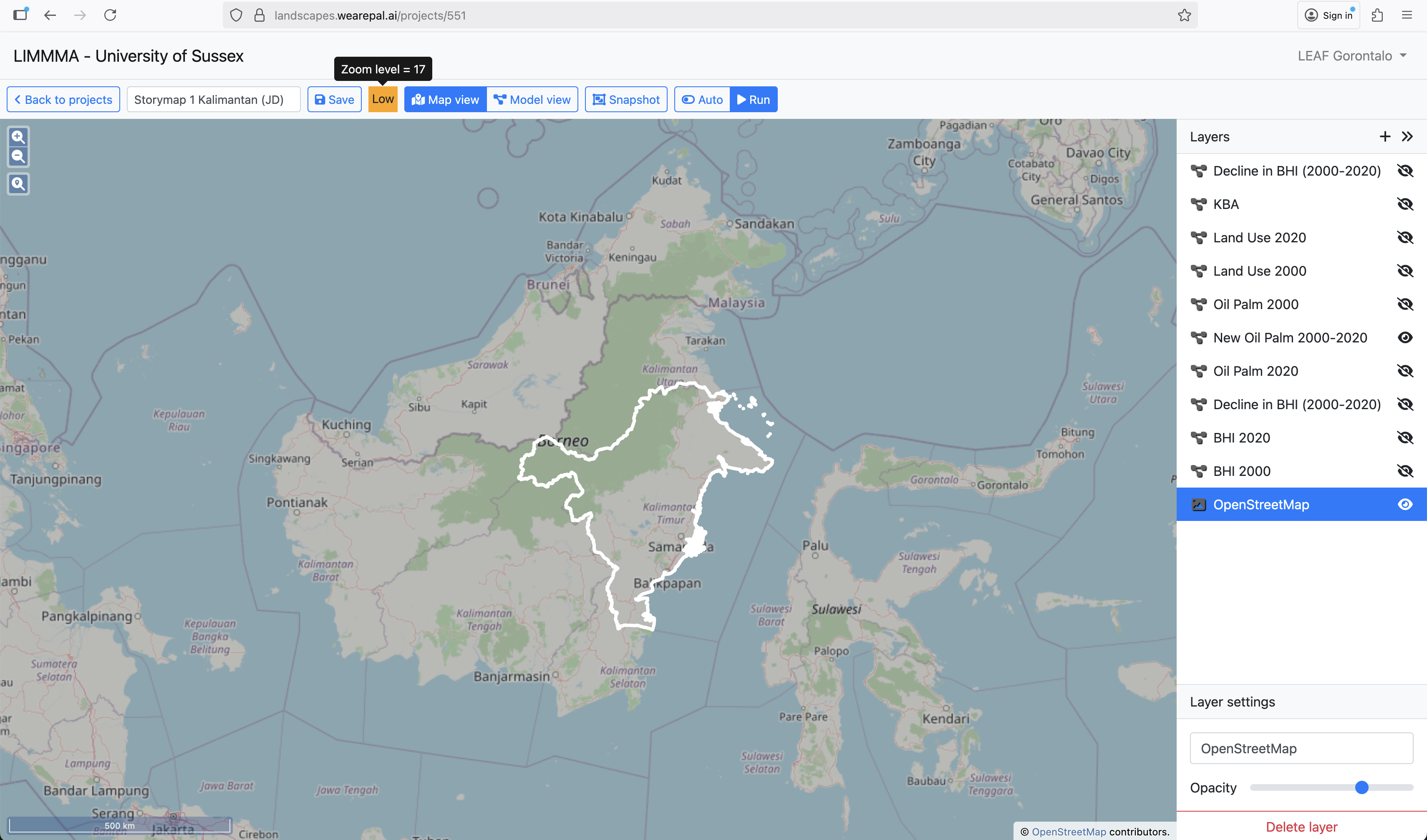
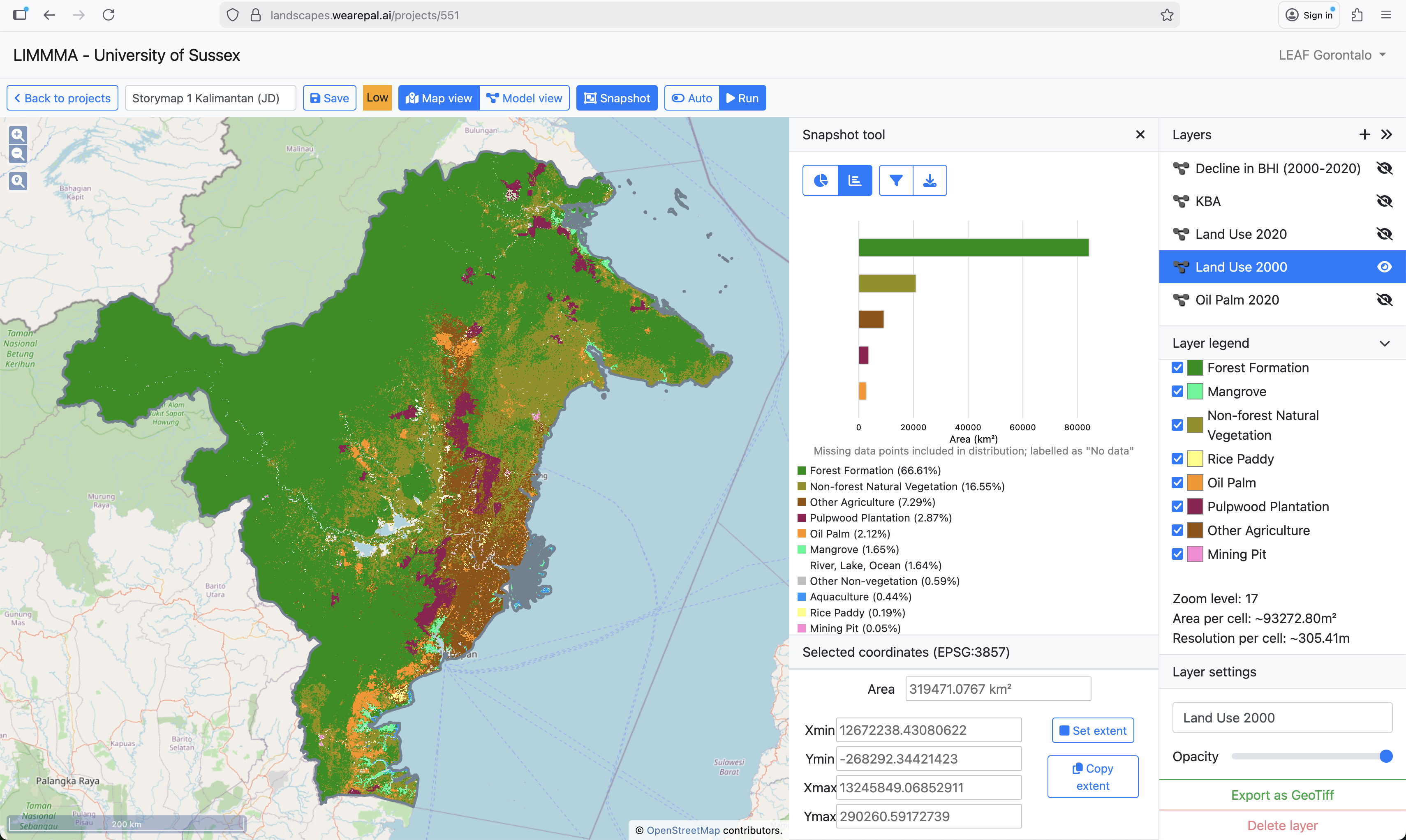
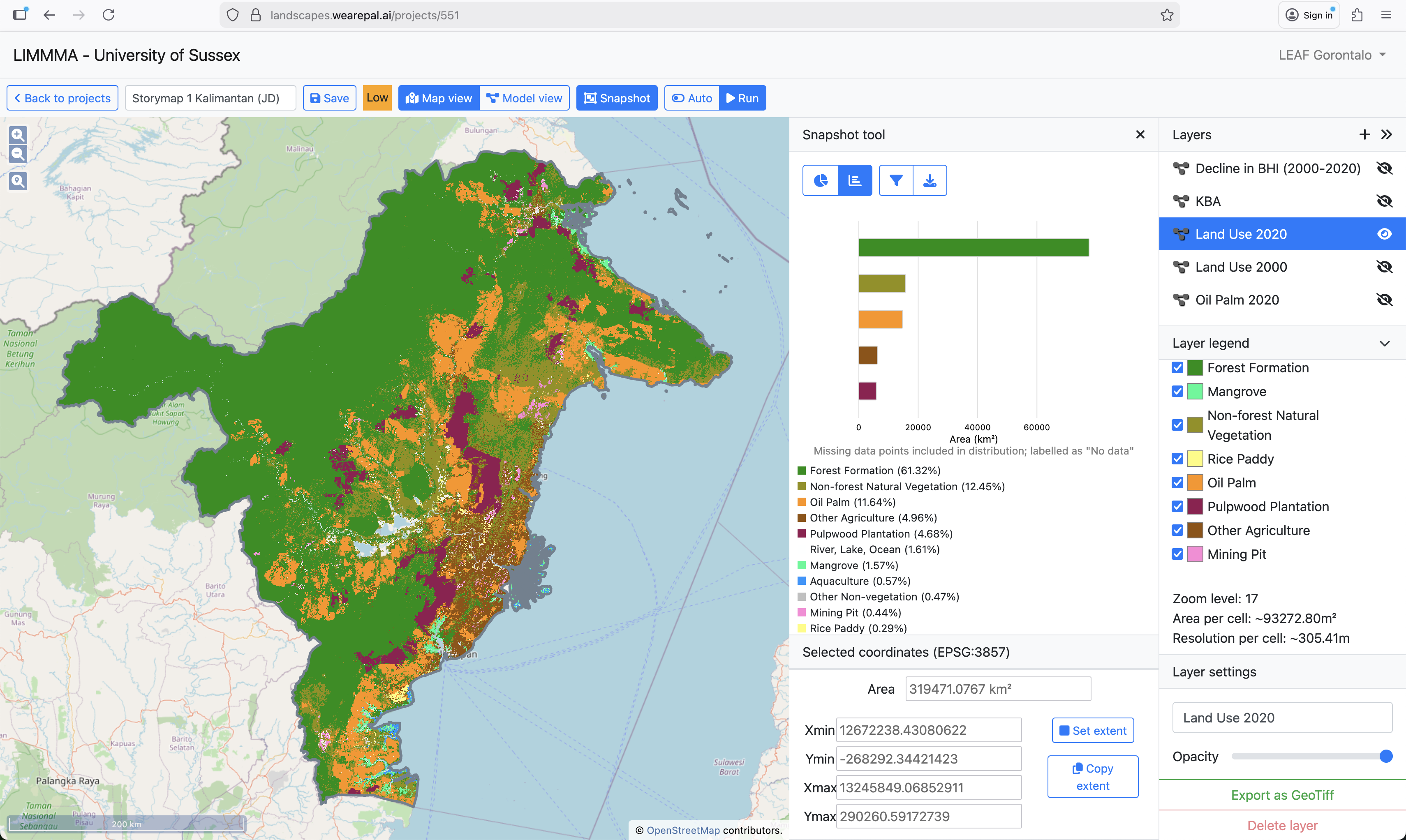
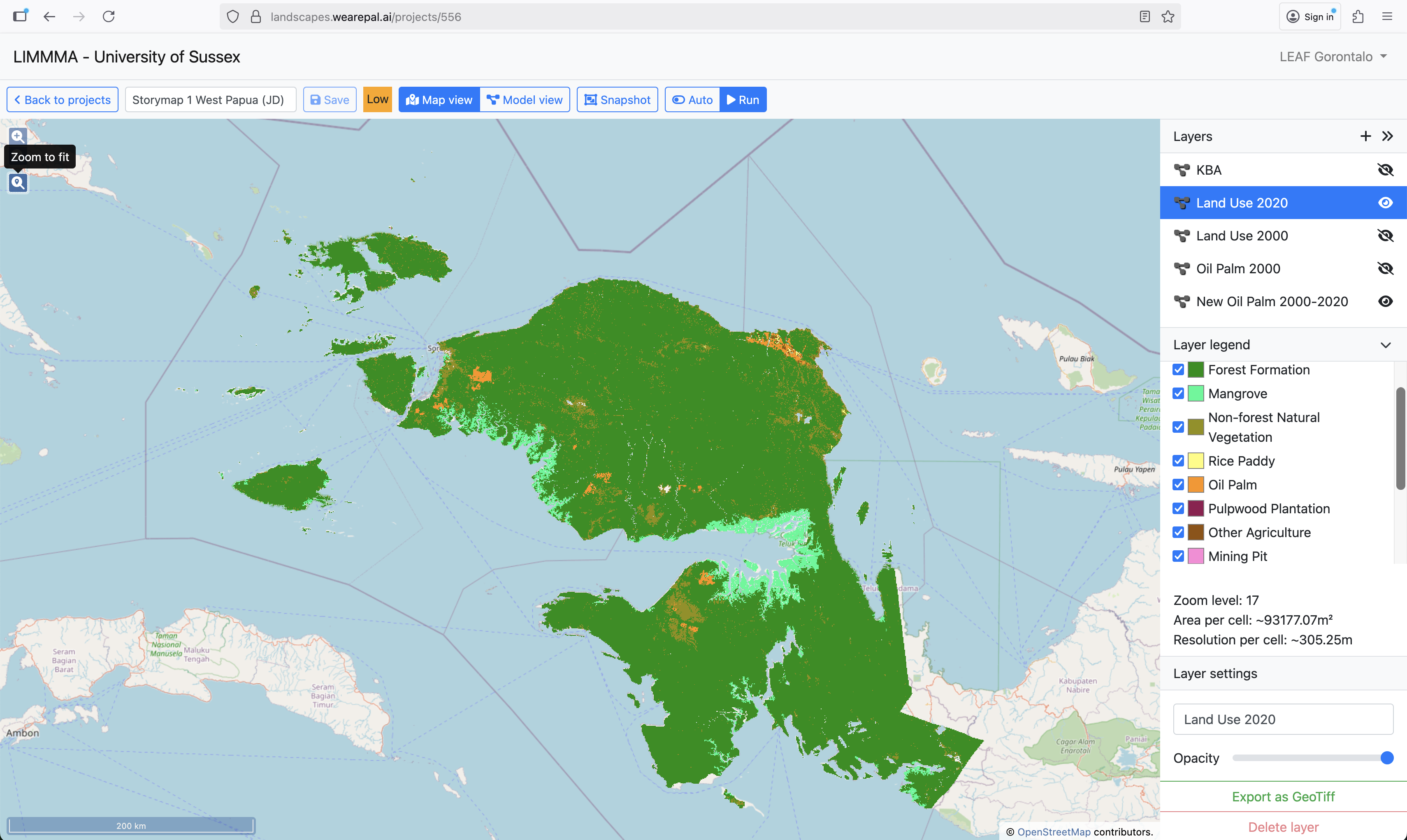
Now let’s see how land-use has changed over time.
Below is a map of land-use in Indonesia from LIMMMA.
Move the slider from right to left to observe how land-use has changed between 2000 (left-hand image) and 2020 (right-hand image).
Notice the expansion of Oil Palm (orange colour) and Pulpwood plantation (in maroon colour) across Kalimantan and Sumatra.
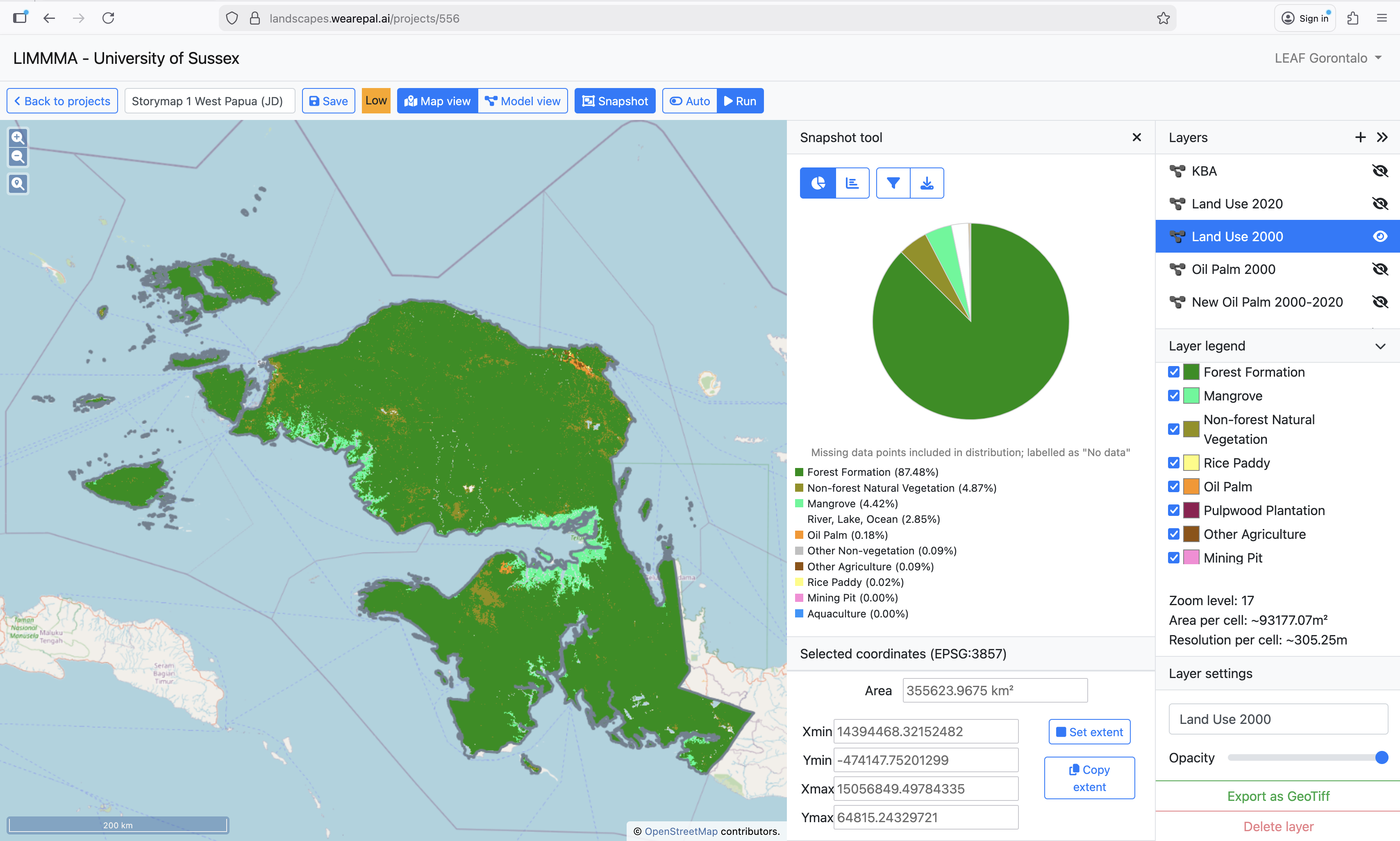
Here on LIMMMA we can see the percentage of land-cover by category in 2000.
By 2020, the percentage of land covered by Oil Palm has increased from 3.88% to 9.14% while Other Agriculture declined from 10.76% to 9.12%.
Meanwhile, Rice Paddy area increased from 4.88% to 5.28%.
While land for food crops is under pressure from plantations and other source of land-use change, farming communities also experience mounting livelihood strains. Local famines, especially in eastern Indonesia, reveal persistent vulnerabilities in food access. Farmers struggle with unstable prices, high costs, and limited market access, while younger generations are leaving agriculture due to low returns and limited innovation. This farmer regeneration crisis, coupled with slow adoption of technology and knowledge, leaves rural livelihoods fragile and food systems less resilient.
In the past 20 years, Indonesia has massively reduced the number of people who experience undernourishment from above 40 million in the early 2000s to consistently below 20 million since 2013.
Source: FAOSTAT
Yet there is still a long way to go to achieve a high level of food sufficiency and security.
In 2024 Indonesia was ranked 77th out of 127 in the Global Hunger Index. It’s score of 16.9 indicates a level of hunger that is moderate.
In 112 of the most food insecure districts, stunting prevalence is above 30% (of the highest public health significance according to the WHO).
Source: WFP. 2024. “Indonesia: Annual Country Report 2024.” World Food Program.
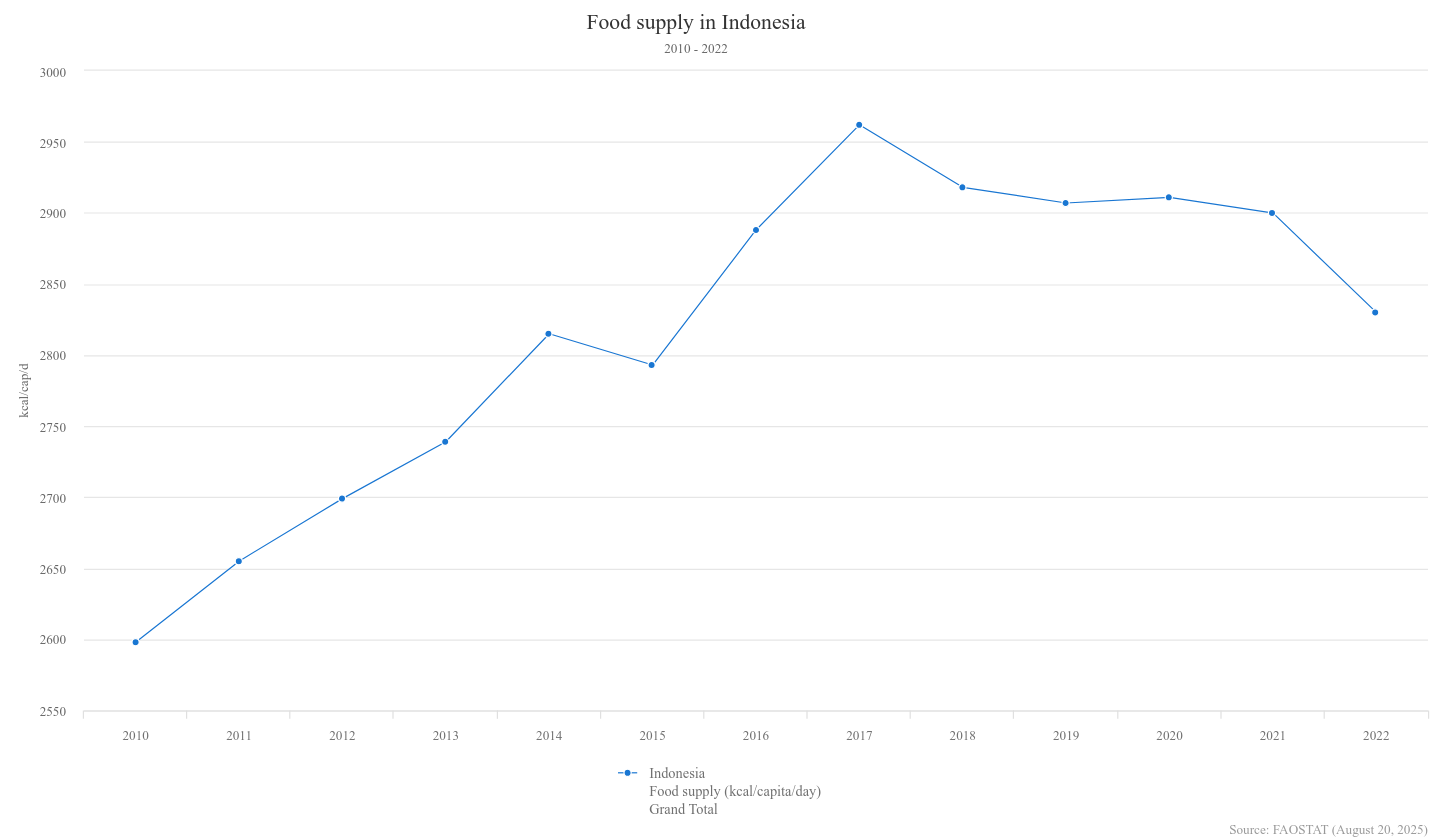
After rising rapidly from 2010, domestic food supply fell sharply from 2017 onwards.
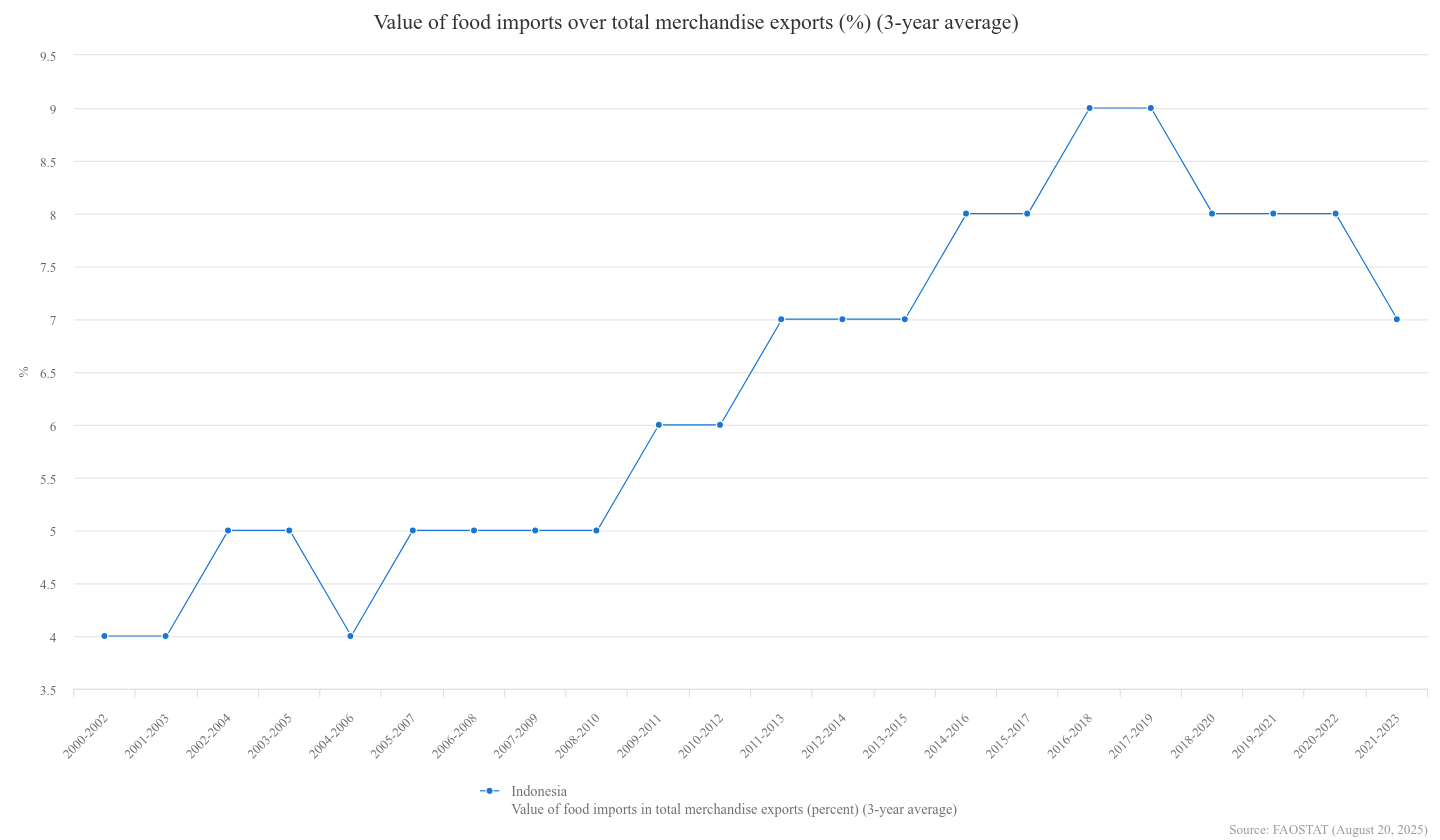
Dependence on food imports, though relatively low, has been rising throughout the 2000s until beginning to fall off after 2019.
After peaking in 2015, rice production began to fall and the average kCal per person per day dropped from a high of 1,260 to below 1,160 for the past four years.
As population increases and the threat of climate change worsens, food sufficiency and security are major issues for Indonesia’s future.
Source: FAOSTAT
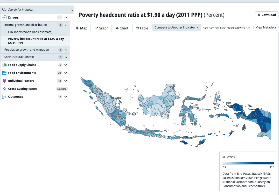
Food security is not only about sufficiency of supply but also a matter of affordability and access to foods of adequate nutritional value. Poverty is a much an issue for food security as agricultural productivity.
By examining the spatial distribution of poverty we see that some districts face a much greater challenge than others and this has implications for food affordability.
The uneven distribution of poverty matches the uneven distribution of food insecurity. Both are concentrated in Eastern Indonesia and the other peripheral areas.
This highlights the complex issues around food distribution and the uneven access to appropriate and affordable foods.
77th
in 2024 Global Hunger Index
26.8%
of children under five are stunted
Underlying these pressures on food security and livelihoods are land and governance challenges. Land expansion for commodity crops reduces space for food farming, while fragmentation of farmland into smaller plots limits efficiency and long-term investment. Indonesia’s diverse geography adds further stress, with mountainous terrain, drought-prone regions, and rising sea levels shaping uneven agricultural viability. On the governance side, centralized and top-down approaches often impose uniform policies that fail to reflect local realities. Limited use of research evidence slows the uptake of climate-smart practices, and the exclusion of women, indigenous peoples, and marginalized groups deepens inequality.
Taken together, these interlinked crises form a cycle in which environmental decline worsens rural hardship, and livelihood strains drive unsustainable practices that further degrade ecosystems. Breaking this cycle requires solutions that link the natural and social dimensions of food security: climate-smart farming and agroecology, farmer regeneration and youth programs, land reform and better spatial planning, and more inclusive, evidence-based governance.
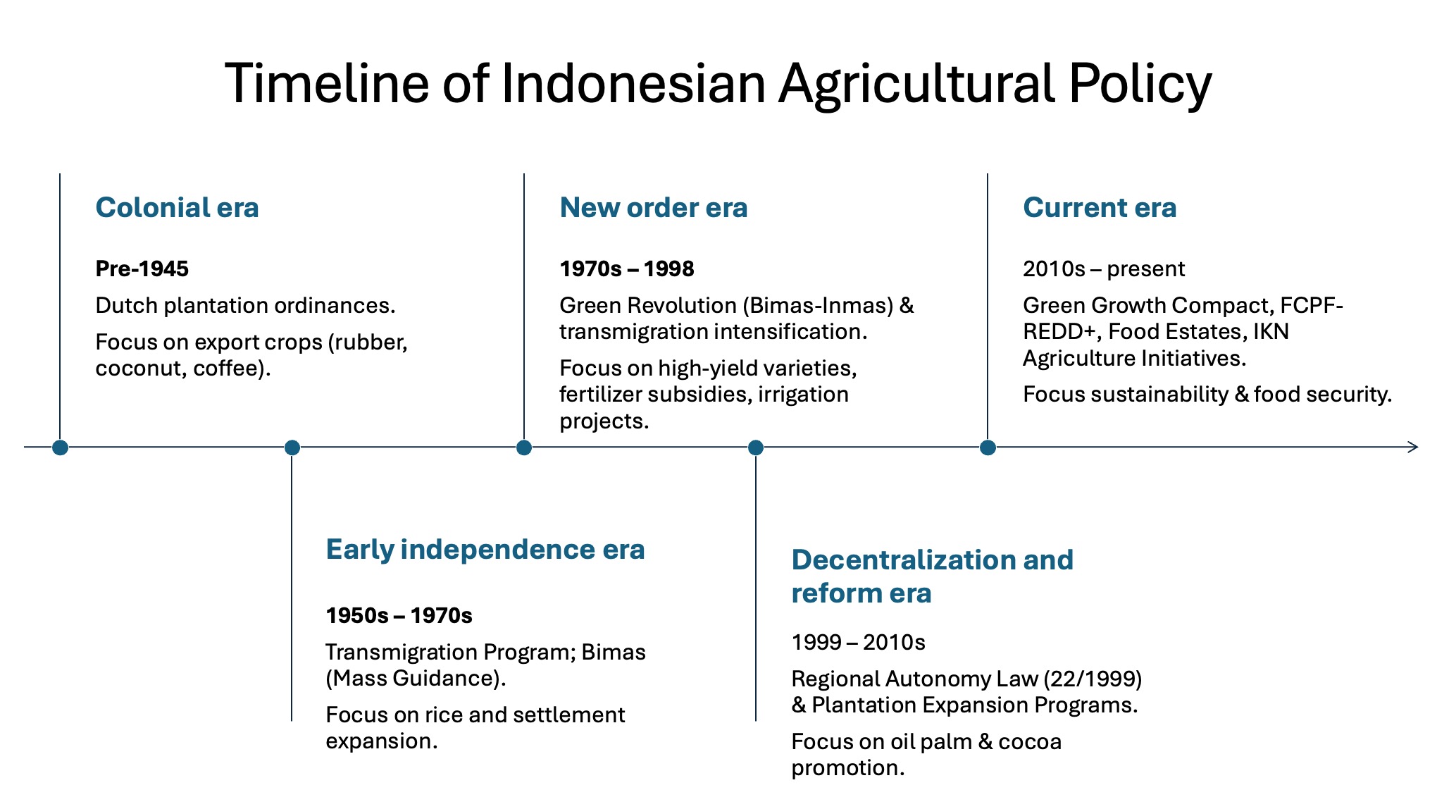
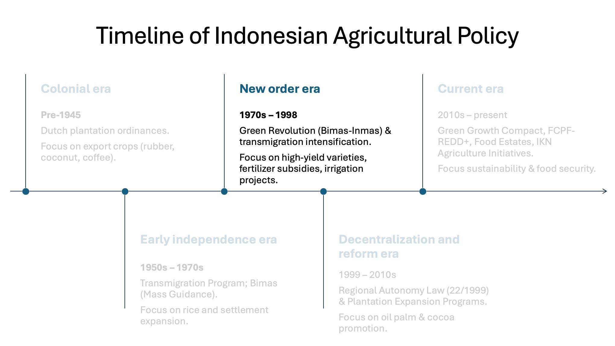
Origins and evolution of food estates
These patterns of land-use are the result of the complex interaction of changing policies, legal frameworks, global and national markets, and local socio-economic trends.
Central to these interactions are the long history of massive state-led agricultural projects which have shaped the landscape since colonial times.
For most of the nineteenth century, the colonial state disrupted indigenous food crop systems through the forced cultivation of export crops and the liberalisation of land for private commercial estates. The Cultivation System implemented from 1830 onwards required village heads to deliver fixed quotas of crops like coffee, sugar, and indigo. This system diverted irrigation and imposed monoculture cropping in place of mixed subsistence farming and marginalised local food systems.
In 1870, the Agrarian Law opened up vast tracts of land to European planters through long-term leases. The focus shifted towards commodities such as tea, sugar, rubber and later palm oil; all destined for global markets. As farmers, freed from forced cultivation, were channelled into these export crop plantations, rice production continued to decline leading to famines in the 1880s.
Finally, in 1905, the colonial state created the Department of Agriculture, Industry and Trade launching programs of irrigation, seed distribution and agricultural education in addition to transmigration programs to reduce land pressure in Java. Despite the colonial government’s gestures towards supporting local food production, the focus remained firmly on plantations for export crops until independence ushered in a new nationalist phase in agricultural policy.
In 1952, Sukarno famously declared: “Why bother talking about political freedom if we don’t have freedom to manage our rice” (Agastia 2023). After several attempts to stabilise rice supply and reduce food imports through state planning and public investment, large-scale state support for staple crops (rice and maize) was established in Indonesia’s first Five-Year Plan (1956-1960).
Subsequently, the Agrarian Law of 1960 and Government Regulation 224/1961 led to land redistribution to landless farmers and an agrarian reform program which cast farmers as subjects of national struggle, not just recipients of state aid. Transmigration programs resettled Javanese peasants to cultivate rice and other staples in the peripheral frontiers of Kalimantan, Sumatra, and Sulawesi in order to populate and develop Indonesia’s outer islands. These early transmigration zones functioned as proto–food estates, combining demographic, economic, and geopolitical objectives.
However, by the early 1960s, Indonesia was suffering multiple food crises triggered by climate disruptions, pest outbreaks and inflationary pressures. Rice import soared but domestic shortages continued until, by 1964-65, Indonesia was on the brink of famine.
This set the stage for Indonesia’s Green Revolution.
Beginning in the late 1960s the Green Revolution took institutional form through the Mass Guidance (BIMAS) and Mass Intensification (INMAS) strategies. Backed by the Asian Development Bank and the World Bank, these programs promoted high-yielding rice varieties, chemical fertilisers, pesticides, mechanised tools, and subsidised credit as a technocratic solution to the perceived stagnation of traditional agriculture.
They were implemented with military discipline. Village cooperatives (KUDs), agricultural extension agents, and local administrators coordinated tightly controlled production cycles in line with central targets. By the early 1980s, rice output had doubled, and Indonesia achieved formal self-sufficiency in rice by 1984, earning praise from the Food and Agriculture Organization (FAO) and development banks that had invested heavily in irrigation, research, and logistics infrastructure.
However, the Green Revolution policies systematically marginalised rural women, landless labourers, and non-Javanese regions (Partasasmita et al. 2019; Theis et al. 2018; Zulfa & Laili 2025). For example, after the introduction of modern hullers to replace traditional milling practices, as many as 1.2 million landless women in Java lost seasonal employment (FAO 1991).
The ecological impacts were equally stark. The heavy use of fertiliser and pesticides degraded soil quality, reduced agrobiodiversity, and triggered pest outbreaks, while irrigation projects disrupted local hydrological cycles. <br
While the Green Revolution reshaped Java’s agricultural core, the New Order simultaneously pursued territorial expansion through its transmigration programme. Rooted in Dutch colonial precedents but vastly scaled up after 1969, transmigration aimed to relocate millions of people – mostly from Java, Bali, and Lombok – to sparsely populated outer islands such as Kalimantan, Sumatra, Sulawesi, and Papua.
The programme promised new land, food security, and agrarian citizenship for land-poor families, while also serving as a mechanism of national integration and frontier control (Li 2007; Potter 2012; Dove 1996).
It positioned food estate projects as tools for state building and demographic engineering, especially in politically sensitive and resource-rich regions.
The transmigration and food estate schemes drew financial support from the World Bank and Asian Development Bank as well as bilateral financing from the Netherlands, USA and Japan for infrastructure, planning and settlement components throughout the 1970s and 1980s.
Between 1969 and 1988, over 3.5 million people were resettled under these projects. Agricultural schemes in these sites promoted rice, cassava, maize, and palm oil cultivation, but often failed to match crop packages to local agroecological conditions. Many areas faced infertile soils, inadequate irrigation, and logistical constraints, resulting in high failure rates and food insecurity.
Among these projects, one failure stands out as a warning to future food estate planners: the Mega Rice Project.
The Mega Rice Project ran from 1995-1999 and converted over one million hectares of Central Kalimantan peatland into planned rice paddies, replacing forest, agroforestry and fishing systems in a massive ecological transformation. Needless to say, the project ended in failure as rice yields failed to match expectations due to the unsuitability of the land.
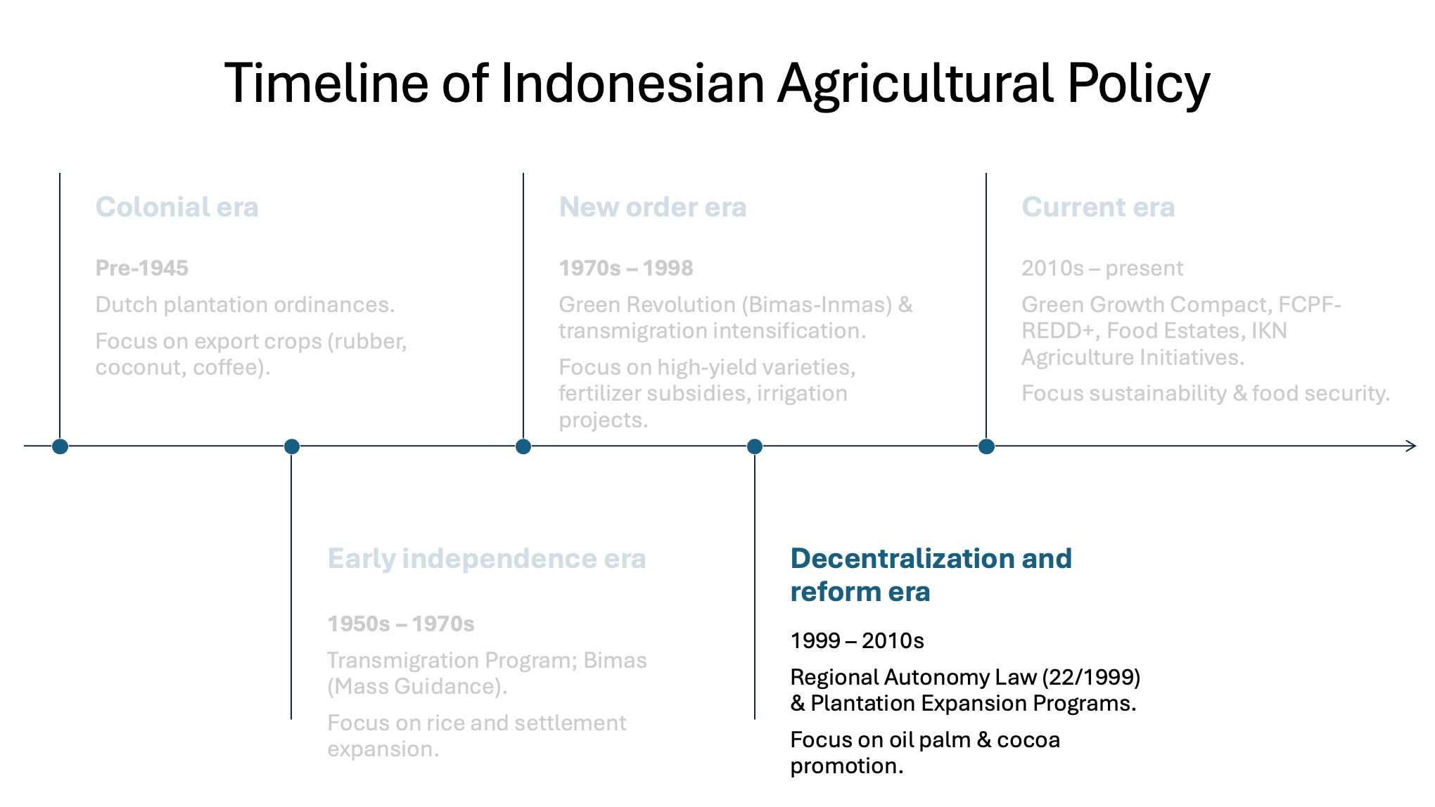
The fall of Suharto in 1998 ushered in an era of decentralisation and democratic reform, generating expectations that rural development would become more inclusive and locally responsive. However, the logic of large-scale food estates did not disappear.
Under Law No. 22/1999, regional governments gained authority over agriculture and land-use, opening space for experimentation with food estate models. Many of these initiatives replicated the extractive patterns of the New Order, channelled through local political networks.
For example in 2010, under President Yudhoyono, the Merauke Integrated Food and Energy Estate (MIFEE) was launched as a frontier model to address food scarcity, energy markets, and Papua’s socioeconomic isolation.
Under this program, more than 1.2 million hectares of customary land were allocated to over 60 agribusiness firms – including domestic conglomerates and foreign investors – for the cultivation of rice, corn, sugarcane, and palm oil (Colchester & Chao 2011; Pusaka Foundation 2015).
The MIFEE led to the large-scale disruption of the lives and livelihoods of the indigenous Marind communities while failing to achieve its stated goals. Instead it led to a decline in local food availability, increasing malnutrition, erosion along waterways and the collapse of traditional livelihoods.
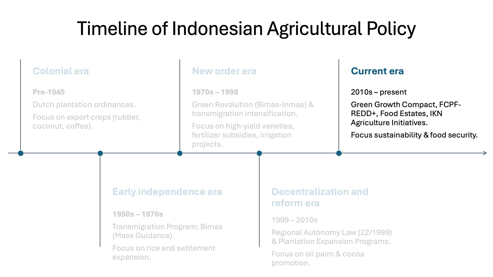
The mid-2010s marked a return to centrally planned food estate projects coinciding with a re-centralisation drive under Joko Widodo (Jokowi). Under Jokowi, the food estate programme emerged as a flagship initiative in the President’s national food security agenda.
Financing of new food estate schemes continued under Perpres 109/2020 as the programme was integrated into national agendas on food security and climate resilience. New laws enable Protected Forests to be converted to Food Security Forest Areas for use as Food Estates in order to meet the new targets.
The food estates programme’s present aim is to achieve rice self-sufficiency by 2027 by converting 4 million ha of land to food crop production and increasing rice production by 10 million additional tons per year (Lou et al. 2025).
1870
1905
1952
1960
1984
1.2 million
lost seasonal employment
1970-1980s
3.5 million
people resettled
One million ha
of peatland converted to rice
1998
Food estates in local context
Having described Indonesia’s food security challenge and the covered the historical context of food estates in Indonesia we now want to introduce you to the three provinces in which we are working.
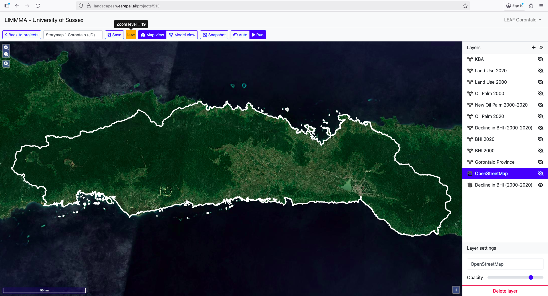
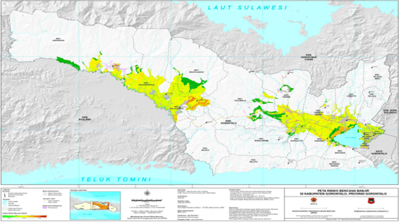
Gorontalo
The province of Gorontalo is located on the northern arm of the island of Sulawesi in a region along the Pacific ‘Ring of Fire.’
It faces the Sulawesi Sea in the north and Tomini Bay in the south.
It’s terrain is dominated by steep hills and mountains with limited lowland areas and it has a tropical climate with two main seasons: a rainy season from October to March and a dry season from April to September.
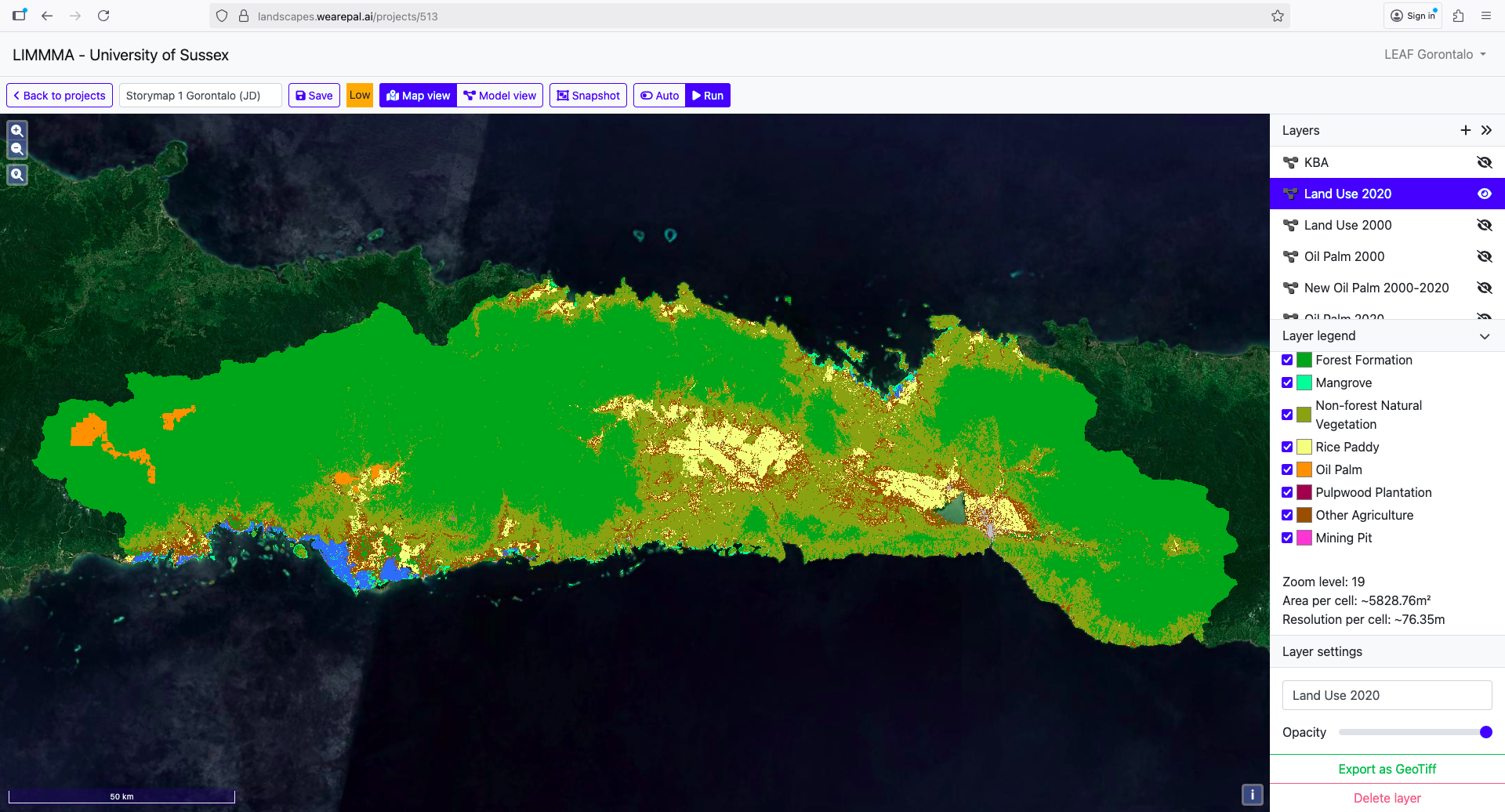
The majority of its land is covered by forest and non-forest natural vegetation while the cultivated land is divided between rice paddy and other agriculture (including corn, coconut, sugar palm etc) with some palm oil in the far west.
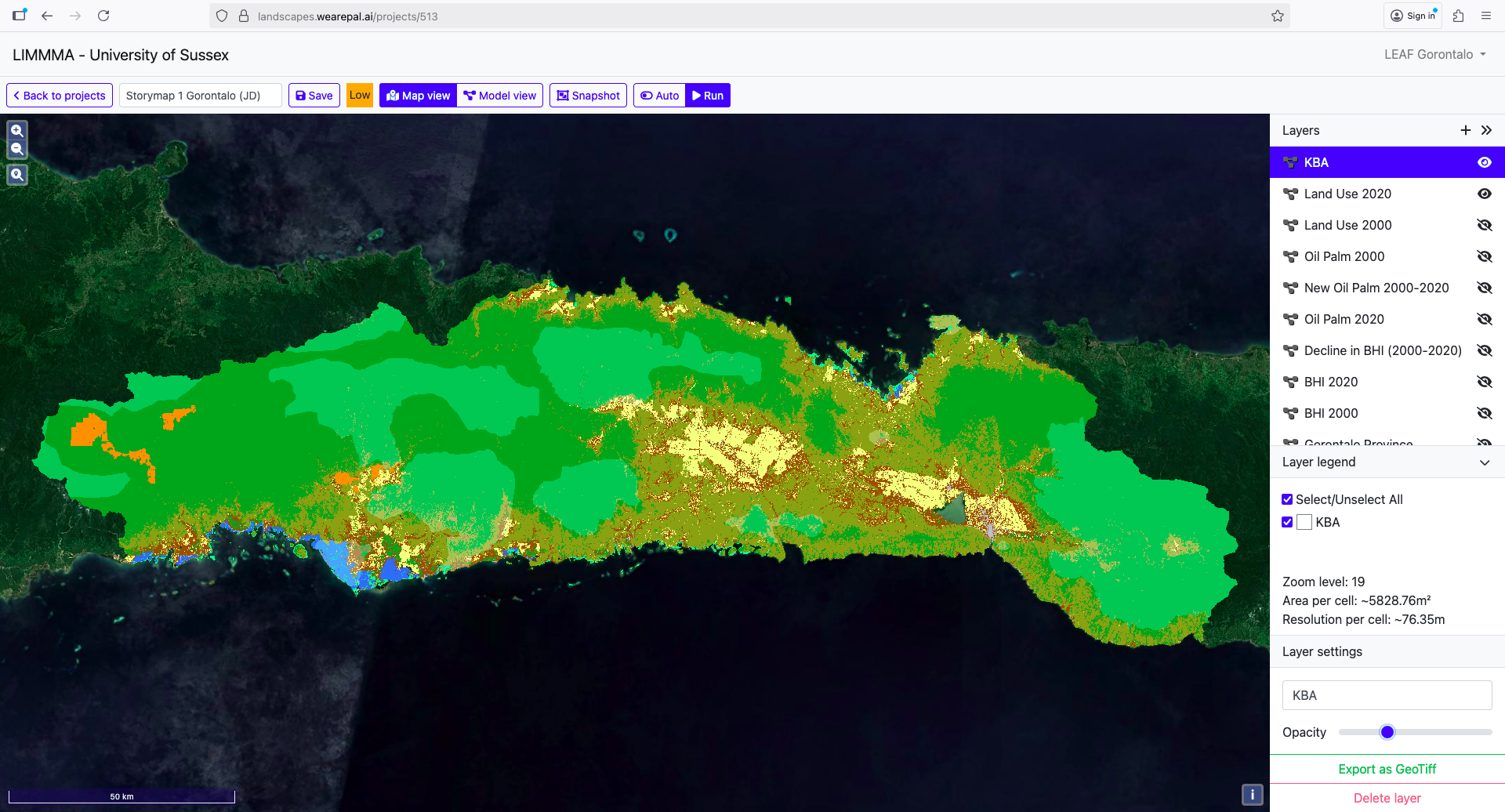
The province contains the Nantu forest, National Parks and several conservation zones rich in biodiversity (see Key Biodiversity Areas) and is home to a variety of endangered species such as the Maleo bird, Babi rusa, and Anoa.
Between 2000 and 2020 the province has seen a substantial increase in Oil Palm plantations, especially in the western part.
Try zooming in for a closer look and adjust the layer visibility to compare land use. Scroll down to activate.
Bogani National Park is spans across Gorontalo Province and North Sulawesi and is a vital source of fresh water resources for downstream communities.
Agricultural in Gorontalo
Driven by the Provincial Food Estate Program, Gorontalo’s agriculture has historically shifted from production of local foods for local consumption to market-oriented cash crops. More recently the environmental and social consequences of this transition have led some to argue for a shift to more sustainable agricultural techniques.
Although land and deforestation statistics are missing, estimates suggest that 82,370 ha of land is critically degraded while on 598 ha have been rehabilitated against a target of 7,094 ha specified in the previous five year plan (RENSTRA DLHK 2025-2029).
Gorontalo’s economy has traditionally been agrarian with corn and many other crops cultivated for local consumption.
Local agricultural knowledge has been passed down through generations and focuses on corn and coconut cultivation while forest communities produce non-timber products such as palm sugar, honey, cloves, and herbal medicine.
Indigenous conservation agriculture features a form of polyculture called Ilengi which is uniquely adapted to Gorontalo’s steep forested slopes.
Ilengi has traditionally been regulated by customary laws such as “Panggoba” and “Huyula”.
Panggoba refers to a traditional method used to determine the right time and conditions for planting or cultivation and is often used to assist in making collective decisions related to crop planting.
Huyula, otherwise known as gotong royong or collective work, is a strong kinship network and practice underpinning mutual cooperation in which people work in shifts and take turns to cultivate each other’s lands.
Ilengi involves planting a combination of various annual crops and productive trees to create a vegetation structure that mimics a natural forest with its multiple layers of plant life from canopy to ground level.
Candlenut, mahogany, bananas and other taller trees form the top layer while sugar palm, clove trees and other shorter trees forms the middle layer below which corn, cassava and other crops can be grown.
This structure and diversity provides habitat for birds, insects and soil microorganisms, supporting a stable ecosystem and maintaining soil structure and fertility.
With a combination of high value products for market and food crops the system supports both economic and food security for farming households.
While Ilengi is suited to steeper slopes, the lowlands and gentler slopes are used widely for cron, coconut, banana, sugar palm.
Coconut plantations produce copra for oil and other derivatives which are often exported, and they can also be combined with corn cultivation.
It is also common to see plantations of coconut with corn planted beneath the trees or “cornconut”! In such cases, due the quirks of property rights, the land and its produce are not necessarily owned by the same people. In fact, the rights to the sell the land, the coconuts or the corn may be each belong to different people!
While these traditional practices persist in many places, a gradual transformation of Gorontalo’s agriculture has been gathering pace.
During the 1980s, Gorontalo’s farmers were pressured to shift from mixed cultivation of native corn for local consumption to monocropping hybrid corn for domestic and international export as animal feed.
Improved yields and government subsidised hybrid seeds, chemical fertilisers and pesticides encouraged widespread take-up but led to dependence on external inputs.
Local consumption shifted from home-grown corn to rice, which was supplied from elsewhere and had to be purchased at the local markets.
Since 2003, corn has been especially important. So much so that Gorontalo is often referred to as the “Province of Corn” due to its high production that supports both local consumption and national supply (mainly for animal feed).
From the 2000s onwards, Gorontalo positioned corn as its flagship commodity through its Food Estate Program called the “Corn Agropolitan” initiative.
Its goal was to increase corn production and establish Gorontalo as a major corn-producing region in Indonesia promoting large-scale corn production in rural areas.
Although the corn program played a vital role in boosting local agricultural production it came with significant costs.
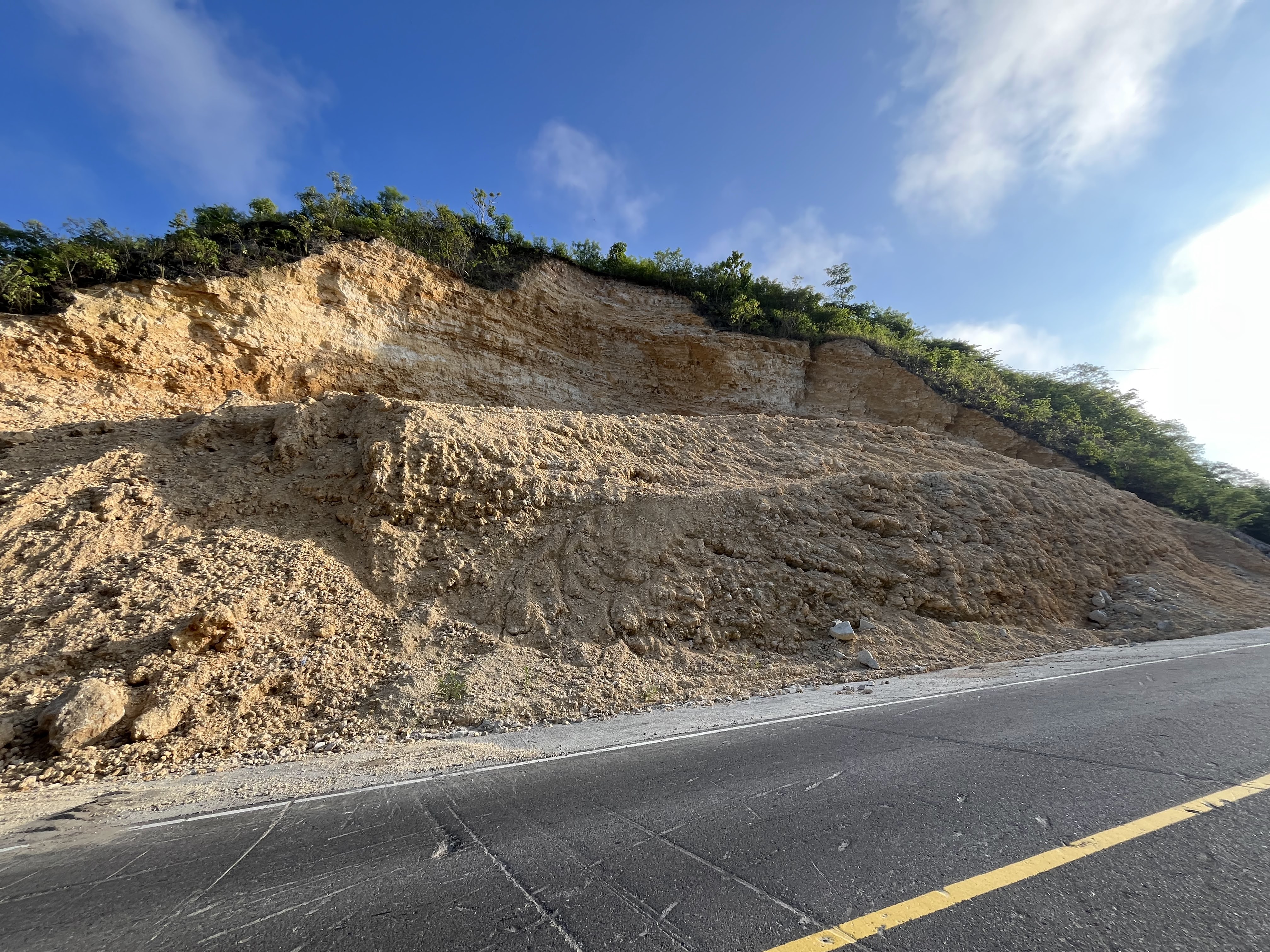
The expansion of monocrop corn farming on steep slopes led to deforestation, soil erosion and the degradation of critical land areas which exacerbated natural disasters such as flooding and droughts.
The area of critically degraded land in Gorontalo increased from 65,414 ha in 2004 to 259,483 ha in 2020.
Initially the shift to market-oriented cash crops contributed to poverty decrease. However, over time it has also increased farmer vulnerability to market fluctuations and rising costs of external inputs.
The state’s demand on food production has also pushed land-use change for corn monoculture farming extensification and estate crops.
Many farming communities are now stuck in debt cycles as declining yields mean that incomes are often falling below the cost of inputs.
Deforestation of the steep slopes of Gorontalo’s foothills not only contributes to soil degradation but also increases the risk of landslides and flash flooding.
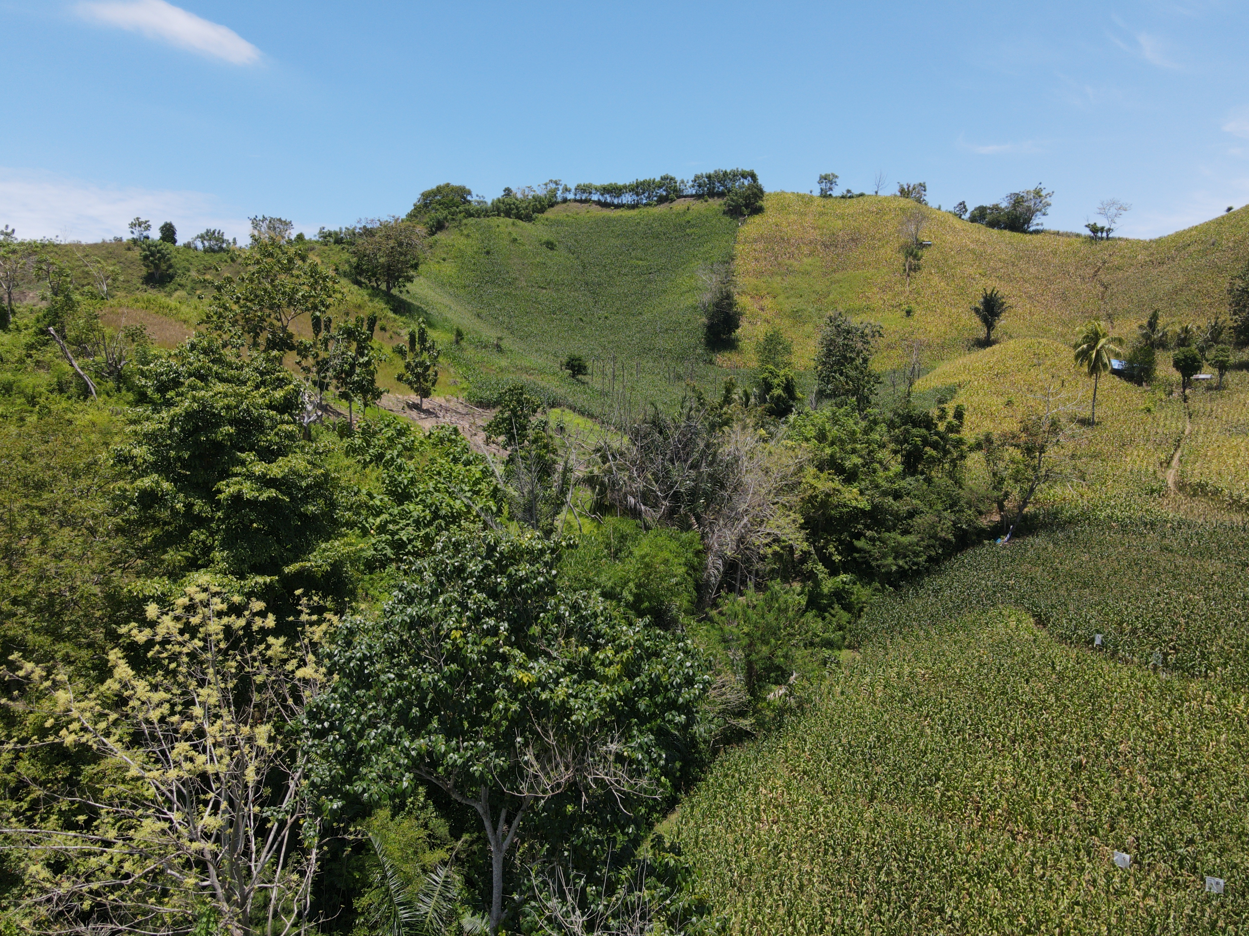
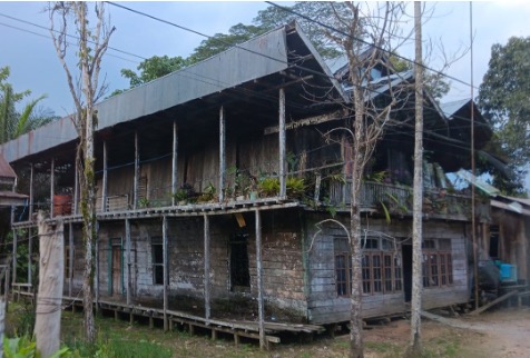
On a recent field visit, our team witnessed first hand the effects of the state-led transition to hybrid corn and chemically supported intensification.
Vulnerability to climate-related hazards
One of the consequences of the agricultural transition from traditional agriculture to chemical-based intensification of monocrop corn is to make rural communities increasingly vulnerable to climate related hazards.
The climate and terrain of Gorontalo make it particularly vulnerable to flash flooding…
…and landslides during the rainy season…
…and droughts in the extended dry season when water shortages impact agriculture and rural communities.
Large areas of Gorontalo are thus vulnerable to climate-related disasters.
Solutions in sustainable agroforestry
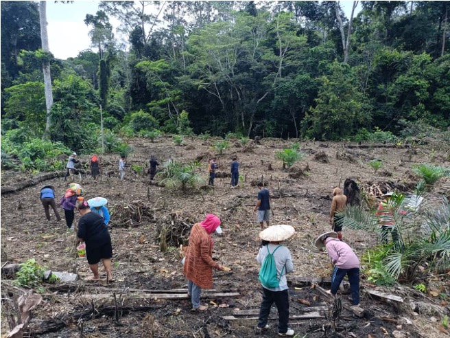
Our team at the Universitas Negeri Gorontalo have recently set up a Living Lab as part of their curriculum for agricultural training. It provides not only a context for training the students (most of whom are the children of corn farmers) but is also a facility for research and the demonstration of sustainable agroforestry techniques.
In our next phase of fieldwork the team in Gorontalo will be working with local communities to understand the impacts of Gorontalo’s agropolitan (food estate) program on local farmers and its implications for poverty, food security, climate and biodiversity.
They will also be working to build local capacity to implement climate resilient agroforestry systems and polyculture farming with the aim of improving livelihoods, food security and environmental outcomes.
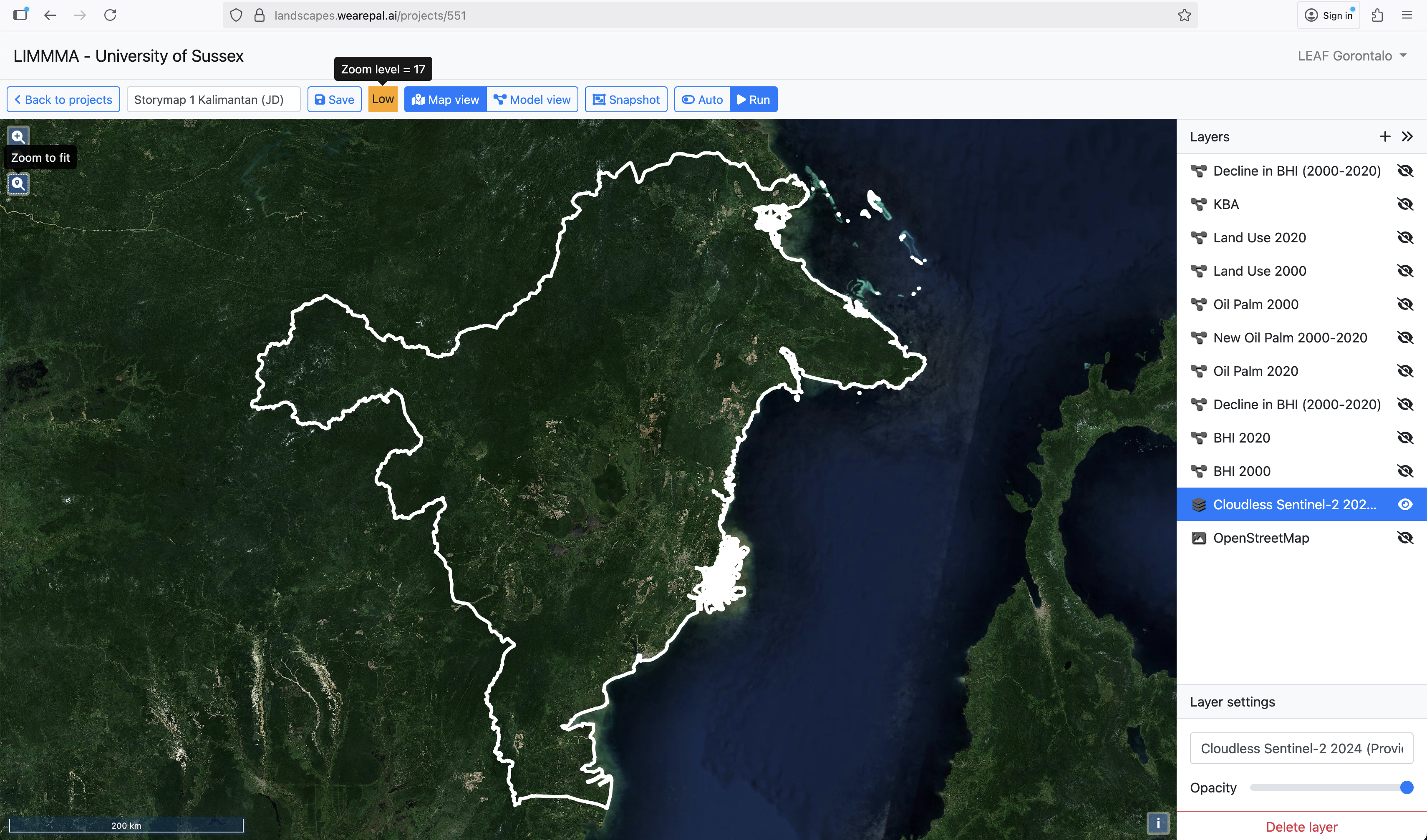
East Kalimantan
East Kalimantan is the fourth largest province in Indonesia at the centre of the archipelago.
It is situated on the east coast of the island of Borneo.
The landscape is dominated by forest, peat and mangrove areas and it has a tropical rainforest climate with two seasons: a wet season between November and April, and a dry season between May to October often coinciding with forest and peat fires (especially during El Niño years).
Decades of land-use change has led to huge areas of land given over to oil palm and pulpwood plantations as well as clusters of mining.
Several of East Kalimantan’s Key Biodiversity Areas are threatened by these land-use changes.
Agriculture in East Kalimantan
In 2000 the majority of agricultural land in East Kalimantan was classified ‘Other Agriculture’ including lowland and upland rice, coffee, cocoa and pepper.
Throughout the 2000s and 2010s upland rice and lowland (paddy) rice have been gradually declining.
And by 2020 the landscape has changed dramatically.
9% of the land area of Kalimantan was converted to Oil Palm between 2000 and 2020.
This change continues a trend beginning in the 1990s of converting forest for plantation crops which has halved the size of primary forest between 1990 and 2023.
East Kalimantan is currently the focus of efforts to transition from ‘brown’ to ‘green’ industries. In practice this means moving from coal mining to oil palm and forest conservation in exchange for carbon credits.
The expansion of oil palm and rice paddy marks a dramatic change in local livelihoods from shifting cultivation to permanent cultivation driven by state subsidies. However, the replacement of other food crops and forest with oil palm, puts increasing pressure on water resources and biodiversity.
The so-called ‘printing’ of rice paddy on lowland areas is supported by irrigation projects and accompanied by large-scale transmigration.
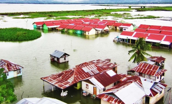
Vulnerability to climate-related hazards
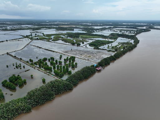
Communities in East Kalimantan experience frequent flooding in river basins and coastal zones.
In 2024 floods inundated 35 villages and large areas of paddy fields.
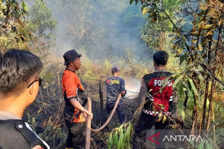
Dry season droughts also cause problems for farmers while forest fires and peatland fires pose a threat to biodiversity and cause massive carbon emissions.
Lembo: climate resilient agriculture
Among the diversity of cropping systems covered by the term ‘other agriculture’, Lembo is one of the most biodiverse and climate resilient.
Lembo is a unique agroforestry practice of the Dayak Tribe in East Kalimantan in which the community work together to open land for shifting cultivation in a patter which allows the forest to recover between periods of cultivation.
It involves is agroforestry and mixed farming systems which integrate rice, fruit, and timber while preserving soil fertility and food resilience.
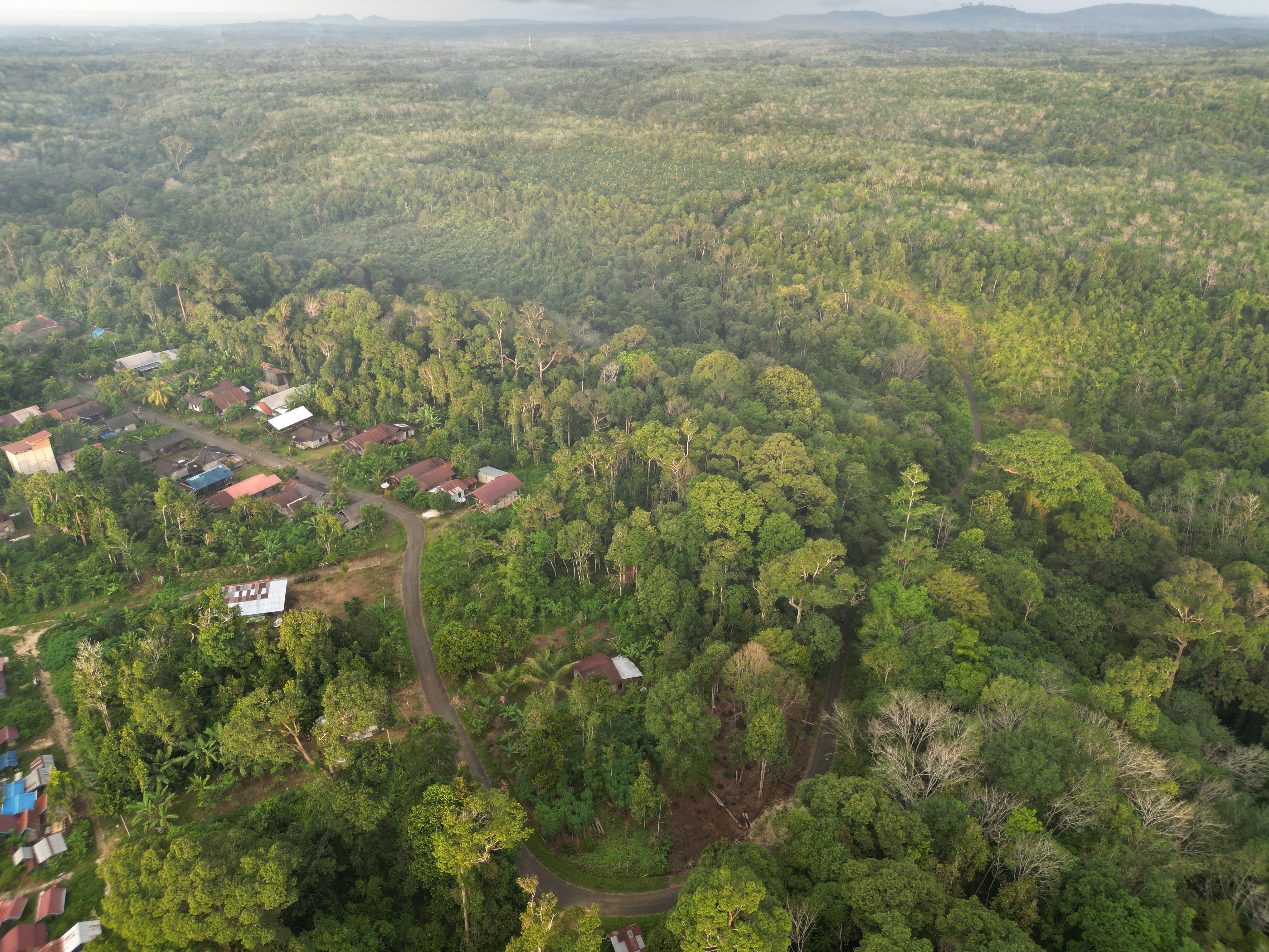
Members of the LEAF Indonesia team visited a village in East Kalimantan where Lembo is still practised. The following video provides a ground level and aerial view of the landscape as it is shaped by Lembo.
Lembo isn’t just a form of agroforestry, but it is also a cultural practise involving collective rituals (e.g., adat harvest festivals) which reinforce sustainable harvest cycles and respect for the land.
However, the practice of Lembo is under threat due to the changing economics of agriculture which are influenced by the government’s Food Estates programs. Farmers are being encouraged to transition from the shifting agriculture of Lembo to permanent cultivation of palm oil while transmigration is deployed to increase areas of lowland rice, often on peatlands unsuited for rice cultivation. In both cases the consequences include soil degradation and increased vulnerability to climate-related hazards.
A sustainable model of Food Estate’s in East Kalimantan will need to adjust incentives to promote sustainable agroforestry and low-external input rice on the most appropriate land, avoiding peatlands unsuited to paddy rice.
West Papua
West Papua is a province in the far eastern side of the Indonesian archipelago with a population of around 4.5 million including between 250-300 tribes and more than 270 local languages.
It is situated on the western arm of Papua on the island of New Guinea.
The landscape is highly diverse, ranging from high mountains, valleys, and lowlands to swamps and coastal areas each with their own distinctive cropping systems.
The vast majority of land is covered by forest and mangroves around many coastal areas. However, oil palm is also prominent as a form of permanent cultivation alongside other agricultural land.
The province is also host to several large Key Biodiversity Areas supporting over 13,600 species of flora, more than 1,000 animal species.
Agriculture in West Papua
Lowland rice, corn, cassava and sweet potato are the main food crops in West Papua while peanuts and soya are also present. Many farming households also engage in horticulture and livestock farming.
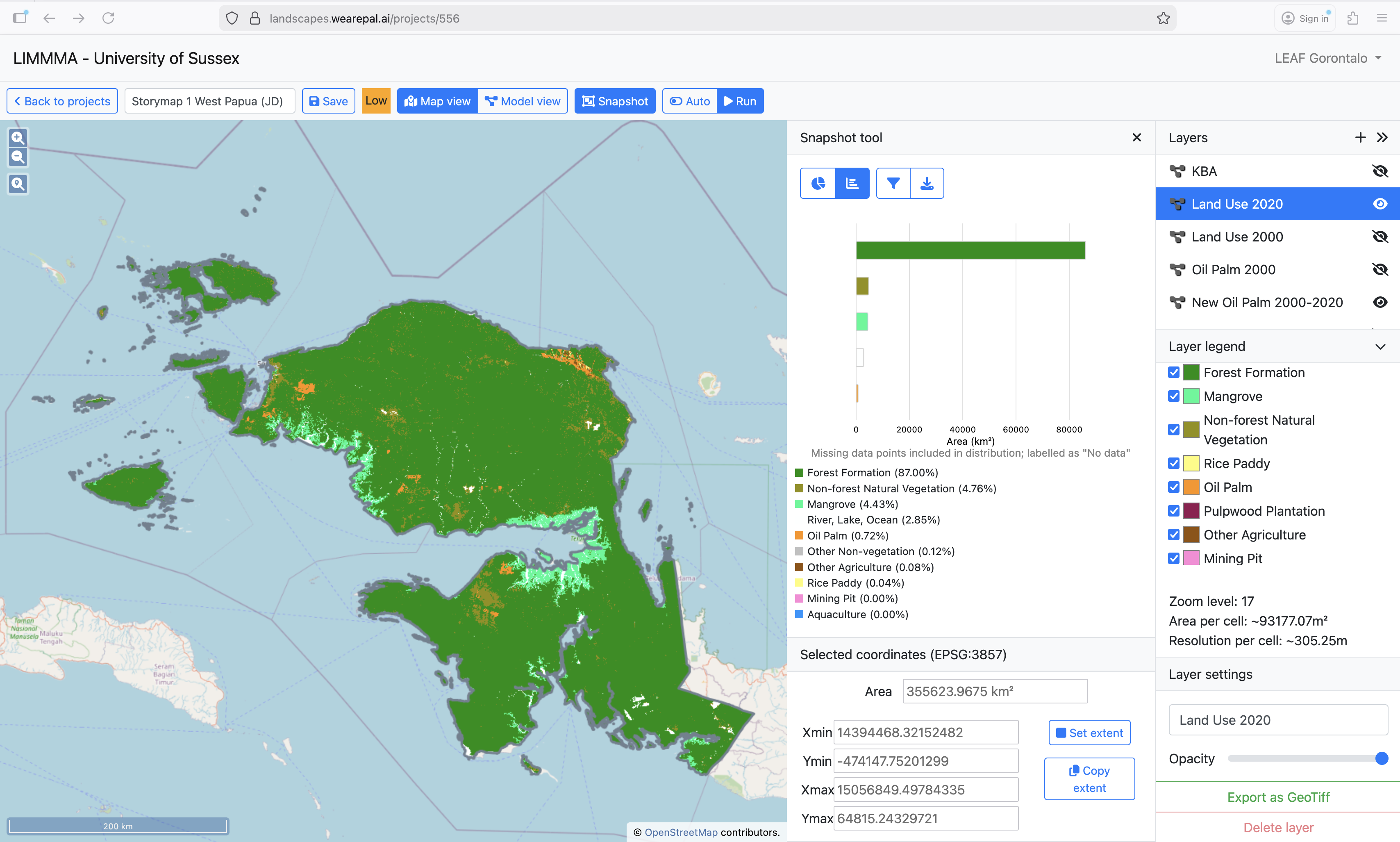
In 2000 rice accounted for 0.02% of land and other agriculture for 0.09% while oil palm stood at 0.18% and mangroves 4.42%.
By 2020 rice area had doubled to 0.04% and oil palm area had quadrupled to 0.72%. In the meantime, mangrove had risen slightly to 4.43% and other agriculture had declined slightly to 0.08.
Oil palm plantations are spreading rapidly and it is likely that food estate schemes will only increase the conversion of forest lands to plantation crops.
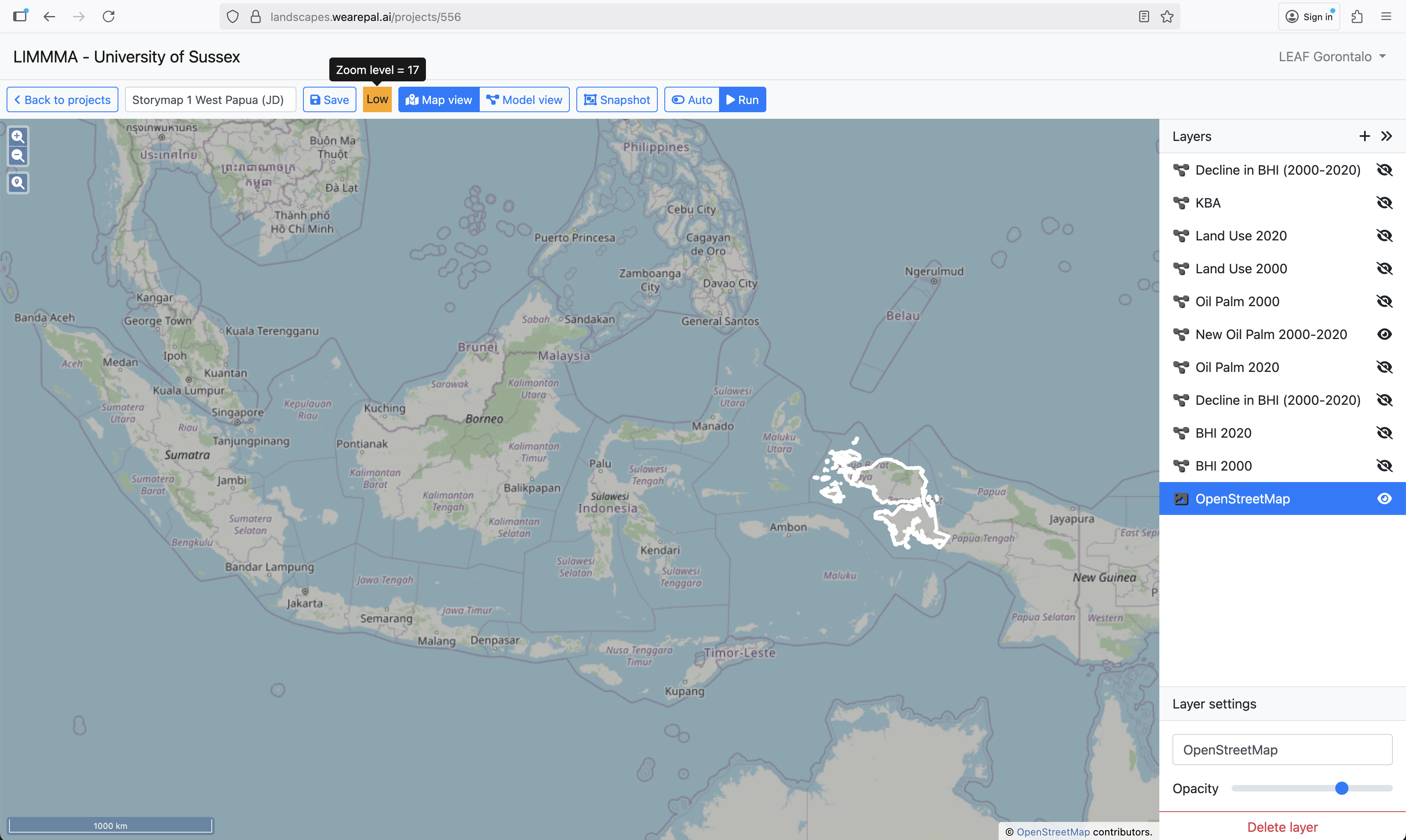
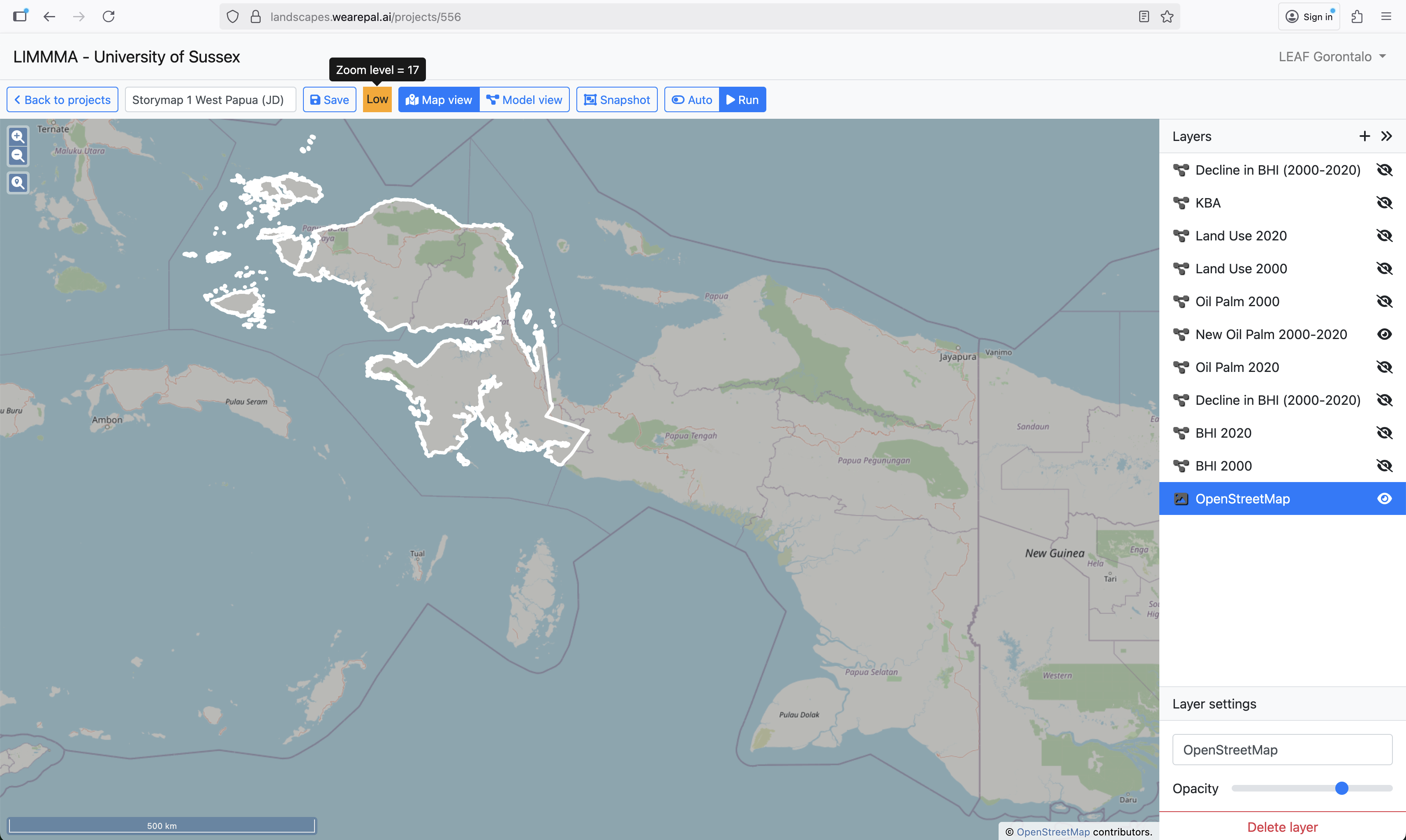
The scale of changes seen more clearly in close up using the slider to reveal the changes between 2000 and 2020. The following sliders show different parts of West Papua in close up.
Western
In the western part there are several large areas of oil palm appearing between 2000 and 2020.
Southern
And a similar situation in the southern part.
Eastern
While the eastern area sees a large-scale expansion of existing palm oil.
In addition to the environmental impacts of deforestation for oil palm, the conversion of forest to oil palm plantation often means encroaching on customary forest lands that have been owned, controlled and managed by indigenous Papuan communities through generations.
This has led to conflicts over land between indigenous communities and companies when land is converted without the consent of indigenous owners.
It also threatens the indigenous practise of sustainable agriculture, Sasi.
Sasi: traditional form of ecological management
Sasi is a form of local wisdom practised by indigenous communities in Papua serving as a customary legal institution to regulate the use of natural resources.
The essence of Sasi is the regulation of alternating periods of harvest or resource use with periods of prohibition (closed season) for land or marine resources.
It not only serves ecological functions but also contains rich social, cultural, legal and economic meanings.
Sasi helps to protect ecological resources while sustaining the supply of food and cash crops such as sago, nutmeg, coconut resin, as well as fish, clams, and sea cucumbers.
Not only does Sasi contribute directly to local food security, but it also forms a social contract which fosters cooperation and solidarity within communities and enhances their resilience.
Erosion of such locally adapted indigenous agroforestry and the cultural heritage which goes with is likely to lead negative impacts on local food security, biodiversity and livelihoods.
Conclusion
In each of the provinces our research teams are exploring in depth the implications of Food Estate Programmes for local communities and farmers. While agricultural livelihoods and the types of Food Estate interventions are different in each province, a common thread links them all.
Agriculture in each province is in the midst of transition from locally adapted indigenous practises to a modernisation of agriculture characterised by cash monocropping for export, supported by increasing dependence on external inputs.
While indigenous practises support local food security and ecological integrity, there is growing evidence that modernisation efforts are responsible for declining soil fertility and increasing vulnerability to climate related hazards which put local livelihoods and long term food security at local and national level at risk.
Our research seeks to highlight the multiple implications of contemporary Food Estate policies and support strategies for locally appropriate Food Estate models which contribute to local and national food security while protecting and recovering ecological resources, supporting rural livelihoods and contributing to climate goals.